

Caribou Falls
If you enjoy my blog, please consider signing up below for email notifications of my latest posts. I will not share your email.

Caribou Falls State Wayside - A Trail Less Travelled
First question - What’s a state wayside? It can be just as pretty as a state park, but it’s smaller. You don’t need a parking pass; they are free to visit. And when you are looking for the road signs, look for blue signs instead of brown.
I have travelled up and down MN-61 several times, but never noticed the pullout for Caribou Falls. It wasn’t until I was staring at a map of the MN State Parks that I realized there was a dot on it for someplace called Caribou Falls. A waterfall I hadn’t been to? This waterfall jumped to the beginning of my hiking itinerary for my most recent trip up north this past October.
This is a beautiful hike along the Caribou River. There may be a few people you pass on the hike, but I don’t think many people know about it. I didn’t see anyone along the trail until I got to the waterfall, and that was just one other family. Its location is very subtly marked along MN-61, with just a blue sign labeled something like “Wayside” with an arrow pointing where to turn, so it’s a place you will only get to with intent, limiting the crowds. The walk along the river was wonderfully quiet. It’s amazing to me each time I head into the woods how I can feel the stress of daily life disappear. I would highly recommend this short but extremely peaceful hike to Caribou Falls.
Caribou River
Location and Parking
The easiest way to navigate to the trailhead for Caribou Falls is simply to enter “Caribou Falls State Wayside” into GoogleMaps. The directions will take you straight to the parking lot. If you’ve lost cell phone service along MN-61, which happens especially if you’re coming from a different hiking location, there will be a blue sign near mile marker 70 off to your left (on the opposite side of the highway than Lake Superior). It won’t say anything about the waterfall, but if I remember it correctly, I think it does say “Wayside.”
If you are driving from Duluth, it’s about 70 minutes away.
If you are coming from the Tettegouche Visitor Center, it’s twelve miles north. From Temperence River State Park, it’s eleven miles south. It’s also twenty miles from the parking lot of George Crosby Manitou State Park (note though that George Crosby is not directly off of MN-61).
When you turn off of MN-61, you will quickly arrive in a pretty large parking lot. There is a pit toilet right next to the trailhead, if you need to use the bathroom. Sometimes that logistic is tricky driving up and down MN-61.
Last thing to note, the same trail to Caribou Falls is an access point to the Superior Hiking Trail. If you are looking for a longer hike, you can just keep going.
This post stands on its own, but it is a part of a larger network of posts I’ve written regarding things to do along Minnesota’s North Shore. This is a link to my full North Shore Guide for anyone interested. It’s an external link so you won’t lose your spot. I will also re-post this link at the end.

Caribou Falls Trailhead
Hike to Caribou Falls
Caribou Falls is a short hike. My GAIA GPS recorded the round trip hike as just barely over 1 mile with an elevation gain of only 100 ft. I thought this was an easy hike. The only accessibility concern is a few steps at the end near the waterfall. I’ve included pictures at the end so you can assess if this is the hike for you, in case that is a concern.

GAIA GPS recording of my hike to Caribou Falls. Each dot represents 0.25 miles.
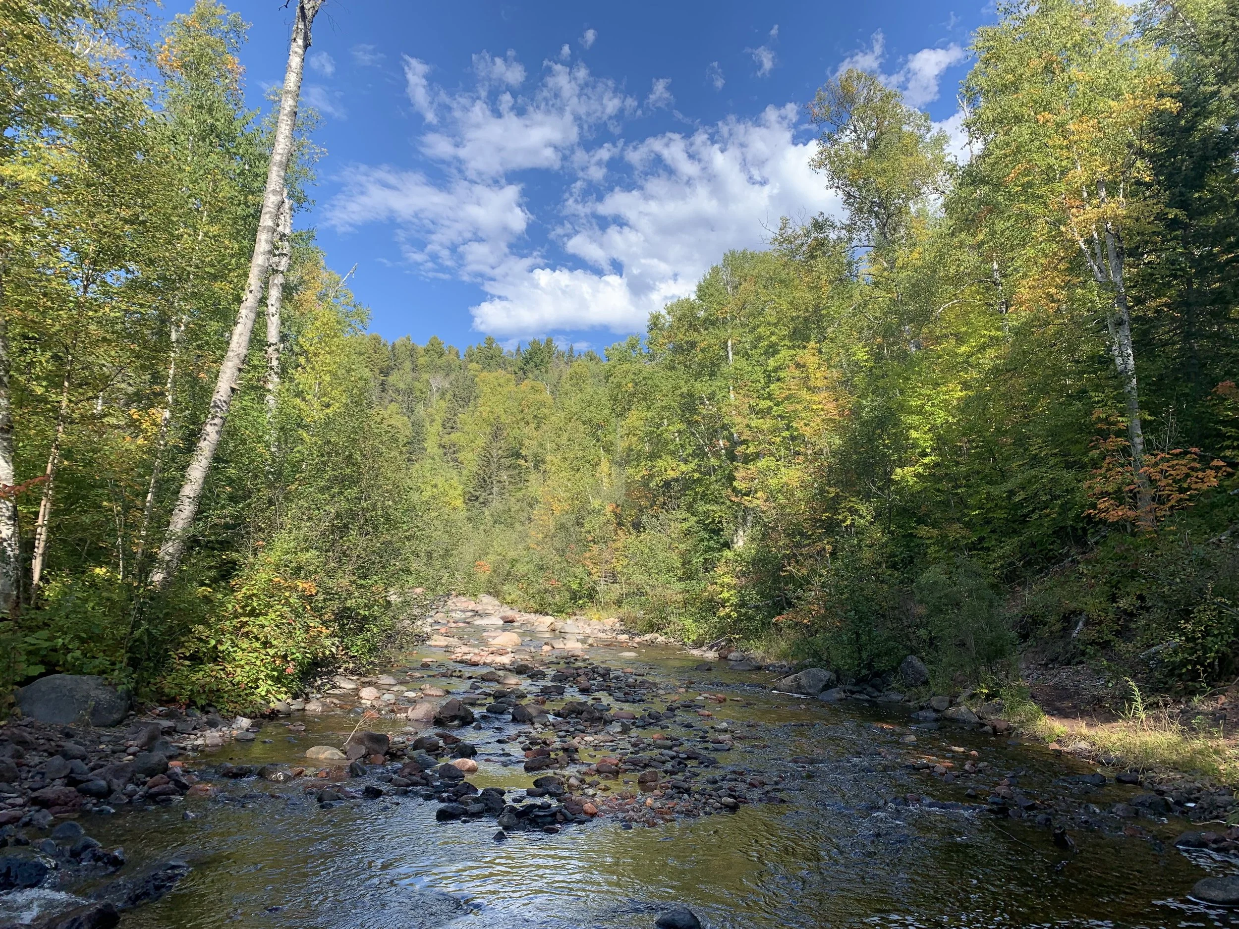
About a 1/10 of a mile into the hike, there will be a fork in the trail. The “official” trail stays to the right. This is a wider trail with less tree roots. I traveled left, towards the Caribou River. This foot trail took me right next to the water the whole way to the waterfall. It got a little narrow in spots, but overall, this part of the trail was still pretty easy of a walk. I’d recommend traveling this way. Stop in a few spots. Stand on some of the rocks in the river and just listen to the sound of the water. Enjoy the solitude.

Caribou River

Caribou River

Caribou River
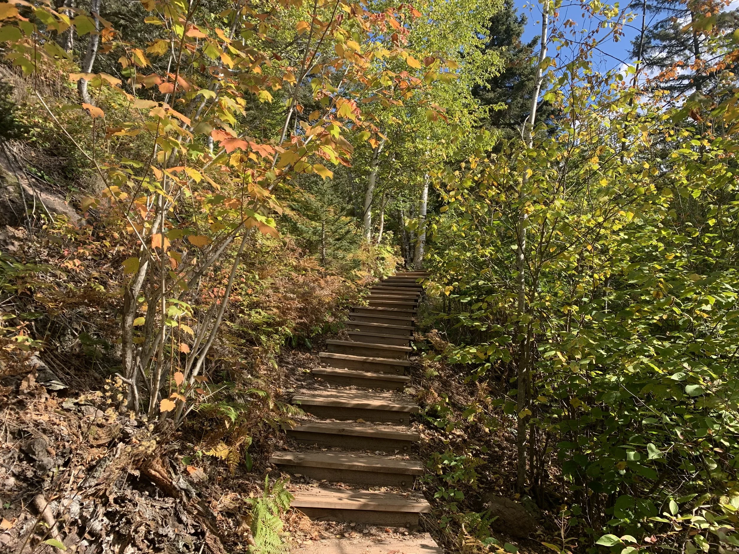
Right before the waterfall, you will realize this trail by the river isn’t the official trail because it intersects with the steps in a slightly odd way, but it’s easy to navigate and walk around to enter the stairs from the main part of the trail, which joins here.

Stairs to Caribou Falls
The short staircase leads you down to the waterfall. Hiking in the fall, there was a nice area to view the waterfall from on the dry ground. There were also a few stepping stones in the shallow river to walk part-way across if you want a better picture.

Caribou Falls

Caribou Falls is an impressive waterfall at 35ft
If there’s a way to make an out-and-back hike into a loop, that’s my number one option, so I took the main trail back to the car. There were just a couple more steps after the main staircase.
Couple more steps
While the trail I took to the waterfall was peaceful as it was on the river and I could hear the water, the way back, I had the perspective where I could now tell I was in a gorge. It was a pretty hike back to the car. I’d recommend trying both trails and make it a loop.

Caribou River Gorge
Other Outdoor Things to Do within an Hour Drive
Below are hyperlinks to other posts I’ve written about things to do that are located within an hour’s drive from Caribou Falls State Wayside.
George Crosby Manitou State Park
(southwest) This is a rustic, quiet, and less travelled MN State Park with one of the more impressive waterfalls in Minnesota.
Tettegouche State Park
(south) This is my favorite MN State Park. There are four waterfall hikes within the park, amazing views of Lake Superior along the cliffs above the water, secret beaches with sea caves, and more inland there are some incredible views from above of smaller lakes (especially gorgeous in the fall colors).
Bear and Bean Lake Loop
(south) Part of both the Superior Hiking Trail and Tettegouche State Park, the Bear and Bean Lake Loop is one of the most popular trails along the North Shore. The views are amazing, and the trail is fun to hike. Be warned though this is a 7-mile loop trail with an elevation gain of 900ft.
Black Beach
(south) This is a free beach on Lake Superior’s shoreline, lined with black rocks. There is an island that can be explored by foot. There are also tables right on the beach, making this my top recommendation for a picnic location.
Split Rock Lighthouse State Park
(south) Pebble Beach is my favorite place to stop and play along the North Shore, and I think the best place in Minnesota to skip rocks. Little Two Harbors is the best short trail to see the lighthouse up close. Split Rock River is the best long trail with small waterfalls and views of Lake Superior. Day Hill is a shorter trail with views of Lake Superior.
Iona’s Beach
(south) This is a free beach on the Lake Superior shoreline, full of beautiful pink rocks.
Gooseberry Falls State Park
(south) Hike to three amazing waterfalls in 1.3 miles. Additional hikes included within the link.
Two Harbors, MN
(south) Not a hiking recommendation, but Betty’s Pies really is a fantastic place to stop for pie!
Sugarloaf Cove
(north) A privately owned section of Lake Superior with an interesting bay protected by rock formations. This park has a small fee and includes its own visitor center.
Sawbill Canoe Outfitter
(northwest) The closest entry to the Boundary Waters Canoe Area from MN-61 is Sawbill Lake. There is a canoe outfitter on the lake where canoes and other gear can be rented. There is a 4.5-mile three-lake trek for a single day exploration, and multiple options for multi-day canoe trips.
Temperance River State Park
(north) This is the most unique State Park along MN-61 where seven waterfalls can be seen in a hike less than 2 miles. Several of these waterfalls occur in dramatic pothole formations. The official MN State Park map undersells this state park, as does the size of the parking lot off of MN-61.
Oberg Mountain
(north) This is overlook hike is part of the Superior Hiking Trail, and therefore parking is free. This is a busier trail, especially in the fall.
Lutsen Ski Resort
(north) Lutsen is the best ski resort in Minnesota. During the summer months, the gondola continues to run. There are hiking trails and a half-mile Alpine Slide.
Cascade River State Park
(north) This park has multiple waterfalls that cascade, making it difficult to provide an actual waterfall count. Similar to Temperance, most of the waterfalls are within a hike less than a mile long. This is also the only MN State Park with a true hike along the Lake Superior Shoreline.
Eagle Mountain
(north) The highest point in Minnesota can be accessed from the BWCA along a 6.5 mile out-and-back trail. This is an easy trail until the last 1/3 of the trail ascends 500ft dramatically. A permit is required, but it’s free, and the paperwork is available at the trailhead.
Grand Marias, MN
(north) My favorite pizza along MN-61 is at Swen & Ole’s Pizza in Grand Marias.
Lake Walk - Superior Hiking Trail
(north) The only section of the Superior Hiking Trail that is along Lake Superior’s shoreline is the Lake Walk, a 1.5 mile stretch of sand / loose gravel, just south of Judge Magney State Park. Note that this is an awesome beach, but a hard place to hike long distances due to the soft ground.
Judge C.R. Magney State Park
(north) This park has two large waterfalls - Upper Falls and Devil’s Kettle.
Link to Full North Shore Guide from NatureImpactsUs.com
For more ideas of things to do up and down MN-61 along Lake Superior, visit my North Shore Guide.
Other Hiking Ideas
If you are looking for more hiking suggestions, please check out my below map which has additional posts linked to each pin.