
Palisade Head at MN Tettegouche State Park
If you enjoy my blog, please consider signing up below for email notifications of my latest posts. I will not share your email.

Create Your Own Adventure at Tettegouche
It’s hard to say that I have just one favorite MN State Park, but if I had to pick, it would be Tettegouche. Tucked into the northeastern part of the state, along the North Shore of Lake Superior, it’s a popular park, but most of the trails are not as crowded as Gooseberry (the closest State Park to Duluth). Tettegouche has several unique areas to explore, some of them feeling quite remote and a bit of a secret. You can easily spend an entire weekend hiking just at Tetteoguche, so I’ll walk you around the park in this post, giving you tips to get the most out of your trip.
Following some logicistics, I’ll cover the must-do’s of the park: Shovel Point, High Falls (and Two Step Falls), and Palisade Head. Then I’ve got a few lesser known areas to share including Mt. Trudee, the Cascades, Illgen Falls, Mt. Baldy, Mic Mac Lake, and Crystal Bay. Towards the end of this post, I have a trail review of the spectacular, and extremely popular, Bear and Bean Lake Loop. I’ll end this post at Black Beach, which is technically outside of Tettegouche State Park, but nearby the other hikes included.

View from Mt Baldy
Location and Parking
Tettegouche State Park is the third State Park along MN-61 traveling north from Duluth (Gooseberry is first, followed by Split Rock Lighthouse). Typically it’s about a 70 minute drive from Duluth.
Tettegouche is large, and there are several different places to park, depending on the trailhead. I will include where to park in the review of each trail below.
This post stands on its own, but it is a part of a larger network of posts I’ve written regarding things to do along Minnesota’s North Shore. This is a link to my full North Shore Guide for anyone interested. It’s an external link so you won’t lose your spot. I will also re-post this link at the end.
Lodging Options
There are two campgrounds within Tettegouche State Park. The Baptism River Campground is the bigger of the two, and includes well-maintained bathrooms and showers. The tent spots are close together, but trees separate most of the sites. For more privacy, there is also a beautiful cart-in campground along the lake shore. I’ve stayed in both campgrounds, and would highly recommend the cart-in sites. However, as the name implies, this does require the use of carts to move things from your car to your campsite, and it’s a bit of a walk. The cart-in campground has pit toilets, but includes the ability to use showers in the other campground without any additional fees. One more thing to note about camping - this is black bear country, so be bear aware. There are bear boxes provided at each campsite, which simplifies how to store food and dishes.

Camping at Baptism River
If camping is not your thing, there are lots of hotels or cabins to pick from. The North Shore is a popular place to travel to in the summer and peak fall color weekends, and the lodging options (campgrounds included) do fill up quickly. Book early.
If you are wondering which city or town to book lodging in, Duluth of course is an option, but Tofte is my top choice for a hotel or cabin. Tofte puts you more at a midpoint on MN-61, so you can drive north or south each day with shorter distances, if you plan to explore beyond just Tettegouche. There is a nice AmericInn if you are traveling with kids. Or if you are looking for something more romantic, consider Eagle Ridge Resort in the nearby Lutsen Mountains. My husband and I stayed at Eagle Ridge on our first anniversary and then at the Cart-in Campground in Tettegouche on our second. Equally wonderful - one had a jetted tub but there were more people around, the other had an amazing private view of Lake Superior but pit toilets… Just depends on what sort of adventure you are looking for.

Tettegouche Cart-In Campground - The cart in the picture is used to move stuff between the parking lot and your camp site. Our view of the lake shore was just past the trees and was part of our site.
Hiking at Tettegouche State Park
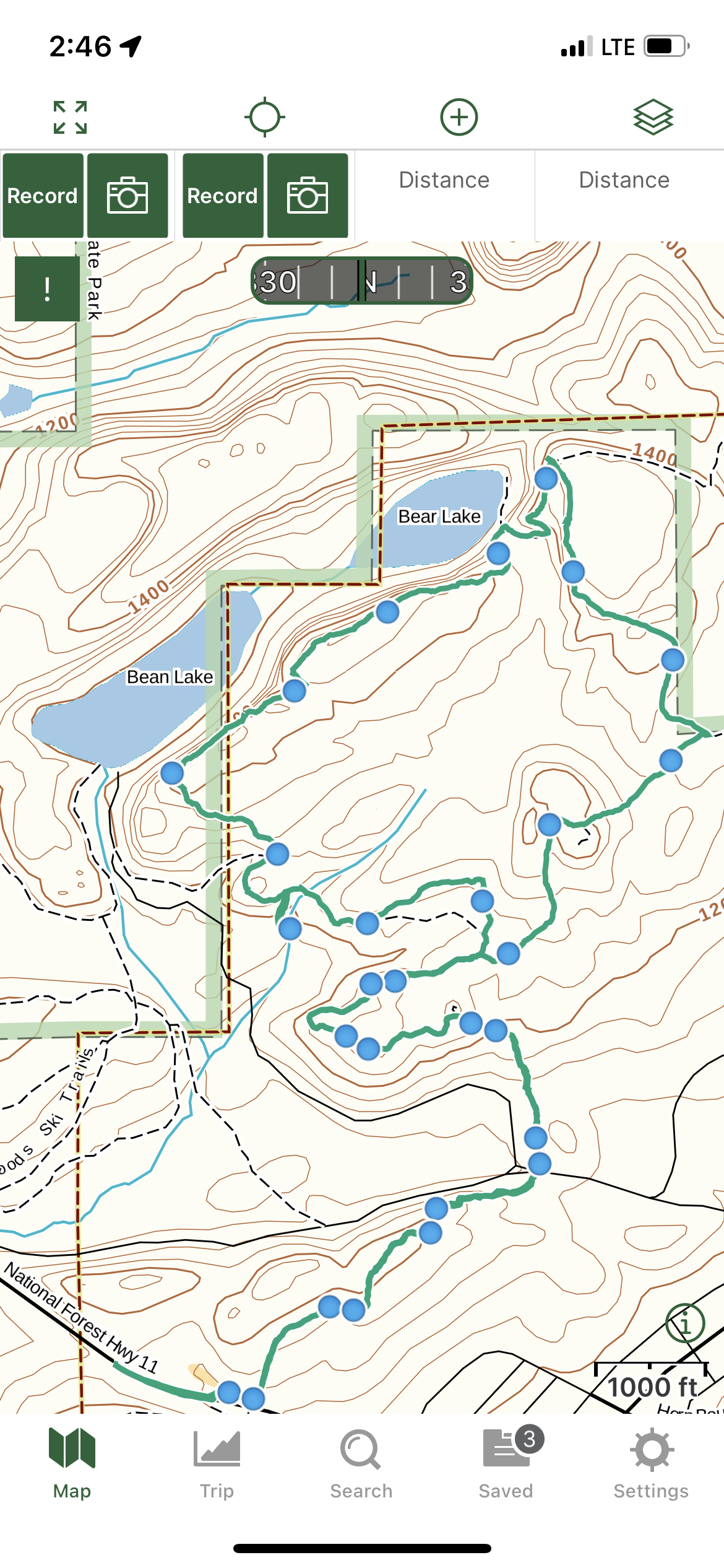
Below is a hiking map of Tettegouche State Park that I will refer to throughout the rest of this post. I’m going to start with the more popular spots in the park including Shovel Point, High Falls and Palisade Head. Then I’ll move counter-clockwise around the park covering the lesser known areas.
I use colors for the trails to help me explain where in the park to find different things. These colors will not mean anything when you are actually hiking. Also included are hyperlinks to each trail in the captions. If you click on the trail name, it will bring you to pictures and a trail description. There will also be a link back to this map at the end of each trail review.
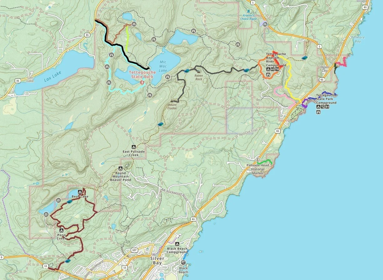
Tettegouche State Park Hiking Map - The app I use while hiking is GAIA
Shovel Point (blue) - Trail walks along the cliffs that drop into Lake Superior
High Falls / Two Step Falls (red, orange, and yellow) - Trails to the largest waterfall in the park and nearby Two Step Falls
Palisade Head (green) - Overlook of the most dramatic cliffs dropping into Lake Superior
Baptism River ( purple) - Trail down to the mouth of the Baptism River as it enters Lake Superior
The Cascades (pink) - Off-the-beaten trail to a cascading waterfall
Mt Trudee (gray) - Impressive viewpoints of Mic Mac, Tettegouche, and Nipisquit Lakes, as well as Lake Superior
Crystal Bay Sea Caves Beach (dark green) - Short trail to a secret beach with visible sea caves
Crystal Bay Point Trail (bright pink) - Rugged trail down to Lake Superior
Illgen Falls (light purple) - Short trail to a quiet waterfall
Mic Mac Lake (black) - Trail follows an old road to access the water’s edge of Mic Mac Lake
Mt. Baldy (brown) - Beautiful viewpoint of Mic Mac, Tettegouche, and Nipisquit Lakes
Tettegouche Lake (aqua) - Trail loops around Tettegouche Lake, but the views are not as pretty as from Mt. Baldy
Bear and Bean Lake Loop (maroon) - Amazing views of Bear and Bean Lakes - this is going to be the busiest trail in the park
Black Beach (light blue) - Outside of Tettegouche, there is an amazing beach of fine black pebbles, with space to explore out to an island in Lake Superior
Tettegouche’s Iconic Views
When I talk with other hikers along the North Shore, the vast majority of people are from MN. This treasure might not yet be very well-known beyond our state borders. If you are Minnesotan, then hopefully you will have multiple trip opportunities in your future. Take your time and pick off a few hikes each trip. I love this part of our state! If you are a planning a vacation from outside of MN, then this may be your one and only chance to see the North Shore. You might be cramming in multiple stops into your trip. So if you only have a few hours, let’s start with the iconic views - the trails you can’t miss.
Shovel Point
1.2 miles (elevation gain - N/A)

View of Shovel Point - Trail goes out to the end of the rocks

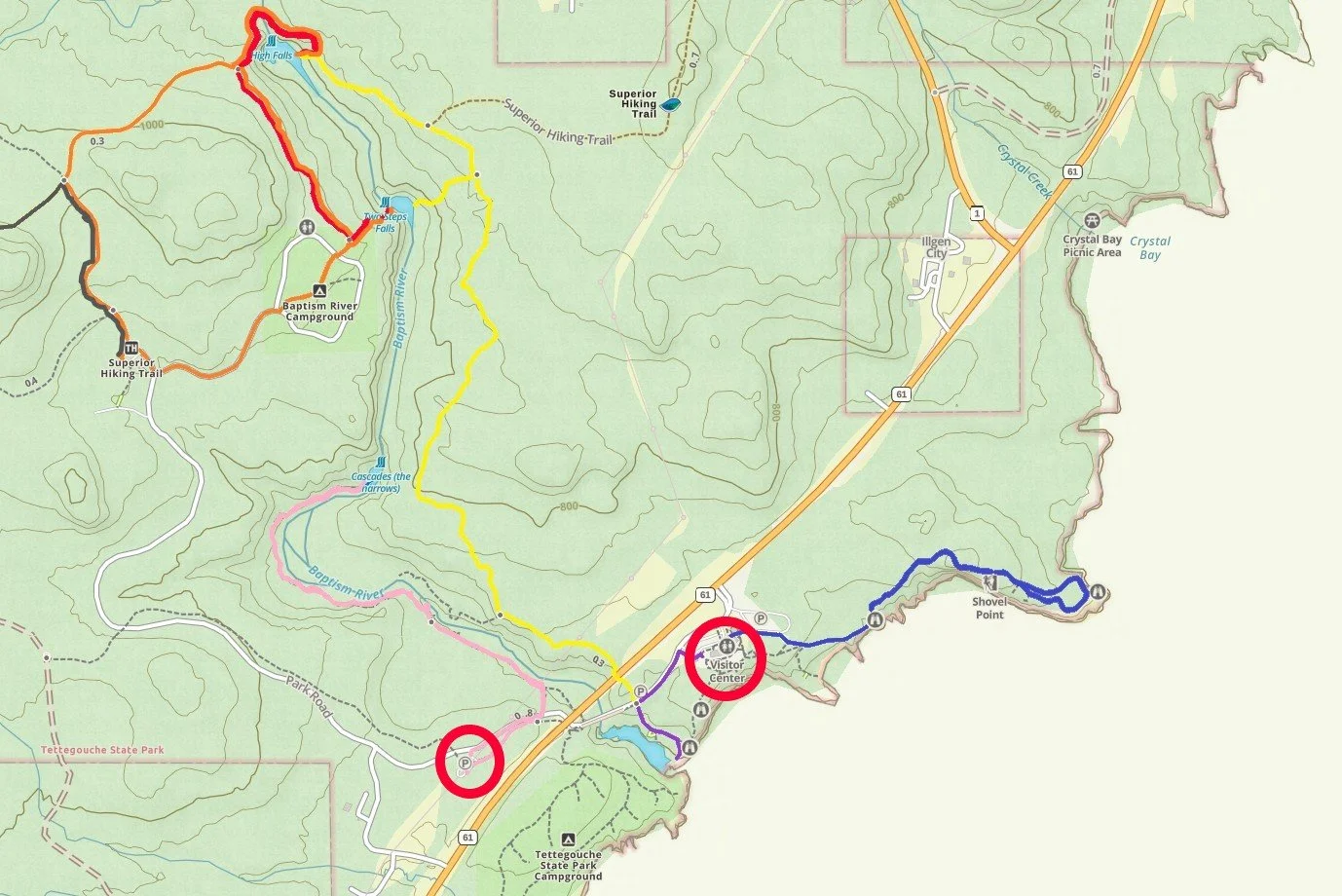
Parking and Trailhead for Shovel Point
Shovel Point is the trail I have marked in blue. To get here, park at the Visitor Center (circled in red), where there are bathrooms if needed. You can also purchase a MN State Park Pass for parking, if you do not already have one. These passes are good for all MN State Parks.

My little hiker on his way out to Shovel Point
Shovel Point travels directly from the Visitor Center to the lakeshore, where you will be high above Lake Superior. I’ve hiked on this trail several times when my boys were little, and I always felt safe with them on this trail, even with the cliffs. There were spots I asked them to hold my hand, however.

View of the cliffs from 2005 - That rock arch has since caved in.

Same view as previous picture, but this is what the arch looks like now
Shovel Point is a short and relatively easy hike out-and-back with a small loop at the end. The colors of the rocks against the blues of the lake are amazing each time I see them.
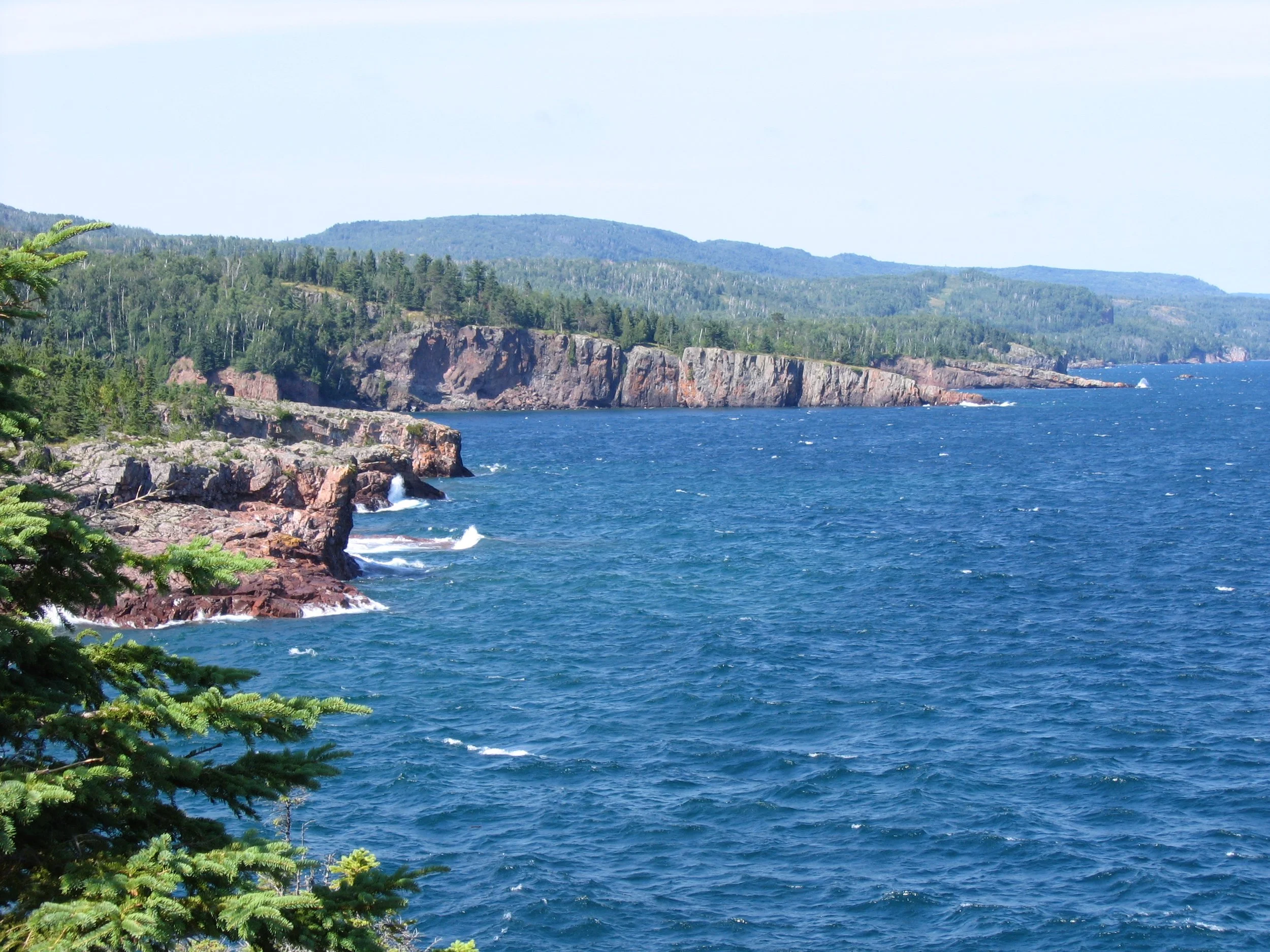
View from the end of Shovel Point - It’s fun to just watch the waves crash onto the cliffs. *Not shown, but Crystal Bay Beach should be visible looking further to the east from Shovel Point.

The view from Shovel Point is nicely guarded for safety - perfect for little hikers
I have to include this picture below of a Pileated Woodpecker, as I look for him every time I’m out on Shovel Point. The last part of the Shovel Point Trail is a loop. This particular woodpecker followed us on one of my treks out here, hopping on the ground, almost the entire way around the loop. These are large birds, and we were starting to get a bit spooked by how close he was following us, and for how long he followed us. Not sure what it was he was trying to tell us - maybe we were just too close to his nest.

Our “stalker” Pileated Woodpecker on Shovel Point
High Falls (and Two Step Falls)
There are three parking options to visit High Falls (parking and trailheads are marked below as the red, orange, and yellow trails). **Note that as of Spring 2023, the swinging bridge over the Baptism River washed out. This isn’t the first time in the park’s history that the bridge has needed to be replaced, but as of 2024, there is no date yet on when that bridge will be replaced. For now, your only option is the yellow trail. Check the official park website for current information, or stop at the Visitor Center.

High Falls - The highest waterfall entirely within Minnesota (Note that there is also a High Falls in Grand Portage State Park - it is higher than the waterfall in Tettegouche, but it is shared with the Canadian border - a bit of controversy over which waterfall is actually the highest in MN as a result of this border issue…)
From the Baptism River Campground (red trail) - This is a 1.2 mile out-and-back hike with an elevation gain of 260ft. This is the shortest hiking option to High Falls. **Note that this trail is not currently passable as the Swinging Bridge has washed away.

Parking for High Falls (and Two Step Falls) from the Campground (red trail)
There is a second parking lot that you would use if you are hiking Mt. Trudee (orange trail) - This is a 2 mile loop hike with an elevation gain of 450ft. There isn’t a real advantage to parking here and walking further, unless the parking lot at the Baptism River Campground is full. **Note that this trail is not currently passable as the Swinging Bridge has washed away.

Parking for High Falls (and Two Step) at the Mt. Trudee trailhead (orange trail)
Your best (and only) option in 2024 (until the Swinging Bridge is repaired), is to park near the Visitor Center. This is marked as the yellow trail There is a parking lot for the Visitor Center (same lot that you would park in for Shovel Point). There is also one more parking lot just a little bit closer if you prefer to move your car and save a couple of steps. This parking lot is circled in red, and High Falls is 3 miles (out-and-back) with an elevation gain of 500 ft.

Parking for High Falls (and Two Step) just past the Visitor Center (yellow trail)
I am still mourning the loss of this swinging bridge… I’m not sure how many times I’ve crossed it, at least 20. I love the High Falls of Tettegouche. Although this bridge is not currently present, and this trail is longer, don’t let that discourage you from visiting High Falls. Hike a bit more and follow the yellow trail.

Swinging bridge over the Baptism River - I loved these tiny bear paw snowshoes that my boys used when they were little. (This is the bridge that recently washed out in spring flooding.)
You do need a bridge to cross the Baptism River upstream of High Falls. Even when the river is partially frozen, you can still here the mighty roar of the water underneath. This trail is not passable without the swinging bridge, even in the wintertime.

View from swinging bridge - top of High Falls

Same view as above from the bridge
The High Falls trail goes right down to the Baptism River. We’ve used the below rock for many family pictures over the years. Usually there are other people down there at the same time who can take our picture, although I’ve never seen this waterfall very busy. When we hike this trail in the winter, we bring a tripod, as most people don’t realize hiking in the snow is a thing, and the entire park is pretty empty.

High Falls - family picture - 2014

Winter hiking - High Falls - 2019

High Falls - Frozen waterfalls are wicked awesome!
If you are winter hiking with kids, my lodging recommendations from above are completely different. Book a room at the Edgewater Hotel in Duluth. There is an awesome indoor waterpark that can be used as bribery to enjoy a few hikes during the day. Be careful which room you book though. Some rooms have only outside entry, meaning you have to walk outside between your room and the waterpark, and that can be really cold when you are wet in the winter. Splurge on the rooms that have access to an indoor hallway. The rooms themselves are not great, but the waterpark makes up for it.
Two Step Falls
Two Step Falls is pretty close to High Falls, and I’ve included the mileage to this waterfall in my hike estimates to High Falls (from all three trailheads). Note that there is no option to cross the Baptism River at Two Step Falls, but you can see the waterfall from both sides of the river.

Two Step Falls - view from yellow trail
The view of Two Step Falls from the trails I have marked in Orange and Red is better.

Two Step Falls - view from the orange and red trails
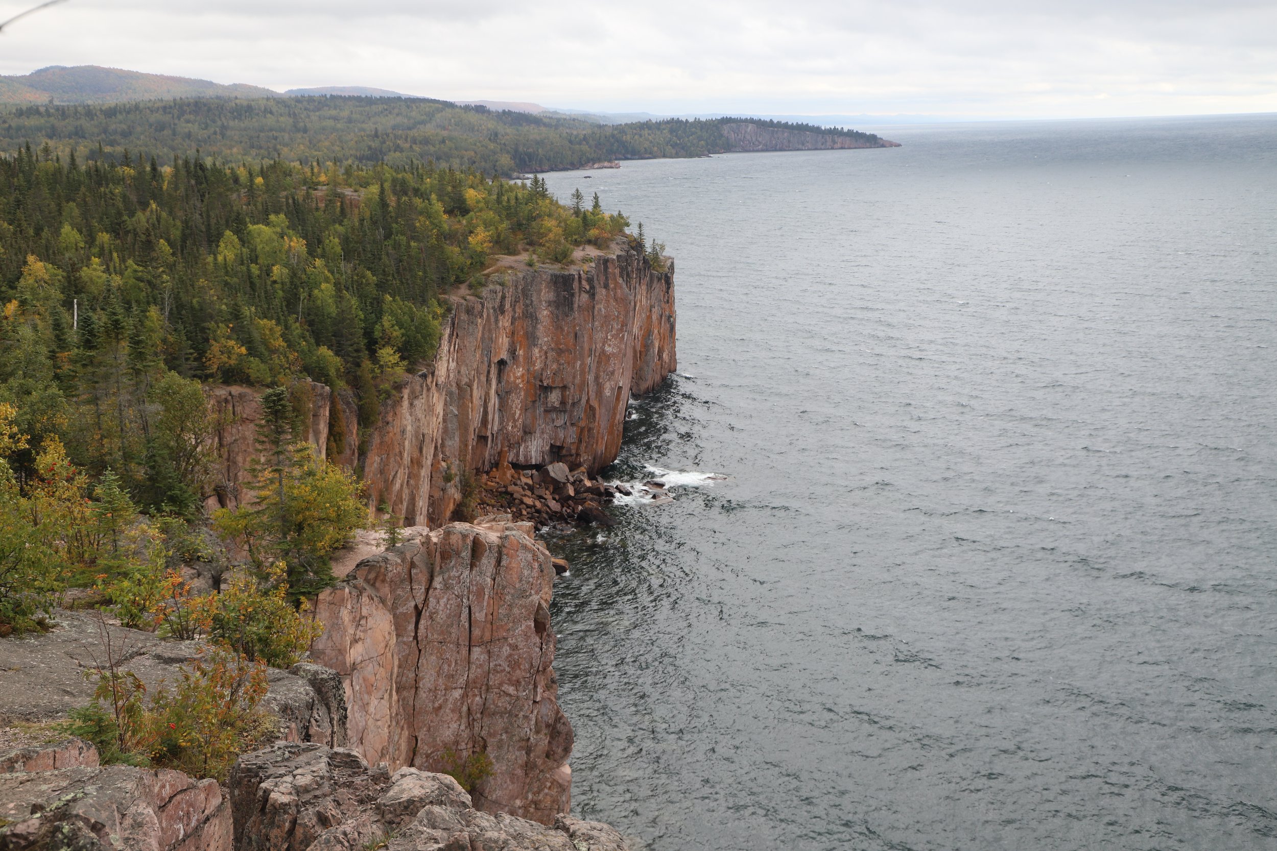
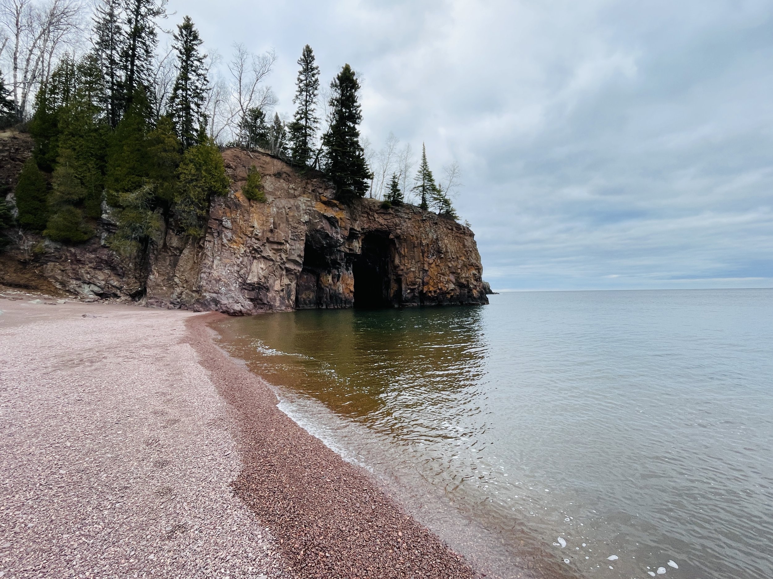
Palisade Head
Miles - N/A, Elevation - N/A
One last iconic view in Tettegouche is Palisade Head. There is only one small guarded wall and lots of places where a young child could slip and fall. This is not a place I would recommend bringing your kids. The heights are dizzying. My youngest was 11 before we ventured here for a family picture.

Palisade Head in Oct 2023

Palisade Head in Sep 2022 on a solo hiking trip

Two parking options for Palisade Head
Palisade Head is marked in green along the shoreline. To get here, get back on MN-61 and go south. There will be a turnout with a parking lot from MN-61. There are two places to park. The first if just after turning off of MN-61. From here to Palisade Head and back is about 1.25 miles with an elevation gain of 300ft. If the park isn’t busy, a second option is to simply drive to the top, and there is a parking lot near the cliffs. The potential problem with this second option is that if it is busy, there is no place to turn around, and you could get stuck in line. We had to wait 30 minutes once as there were more cars up there than we expected. Unfortunately there isn’t a way to know if there’s going to be a line of cars at the top.

Palisade Head
Tettegouche’s Secret Spots
If you have more time, there is so much more of this park to see. And beyond the above popular spots, these places are pretty quiet.
From the Visitor Center or Cart-In Campground parking lots, I have two suggestions: 1) Play in the Baptism River 2) Hike to Cascade Falls
Parking for the Cascades and trailhead to the end of the Baptism River
Baptism River’s End
0.6 miles + any distance you walk in or along the river (100 ft elevation). This trail is marked in purple.
Lake Superior is much too cold to swim in, but in July and August the Baptism River is an awesome place to get wet. Take off your shoes, or bring some water shoes and a swimsuit, and hike in the Baptism River. This will feel fantastic after a hot day of hiking. One year we found a ton of crayfish hiding under the rocks in this river.

This is the closest parking lot to get to the Baptism River. It’s just after the Visitor Center, before crossing the bridge over the river. There are only a small number of spots.

Across from the parking lot, there will be a staircase that descends a short distance to the river.

Looking upstream, the MN-61 bridge is visible

Keep walking out on the rocky beach. To the left, you get a nice view of Shovel Point. Keep walking a bit around the corner, especially in the winter.

One of the most amazing scenes I’ve witnessed with frozen water

“Phenomenal” doesn’t begin to describe this

Same beach in the summer
The Cascades
1.8 miles out-and-back hike (100 ft elevation) - this trail is marked in pink.

The Cascades

Parking for the Cascades and trailhead to the end of the Baptism River
The Cascades waterfall is only accessible from one trailhead. Walk down the road from either the Visitor Center or the Cart-In Campground until you see the below trailhead sign.

Trailhead for the Cascades
The Cascades is one of the best hikes in Tettegouche. It’s quiet, easy (with the exception of needing a bit of navigation over the rocks at the end), and it’s in the busy part of the park but no one seems to know about it. The trail follows the Baptism River upstream, with several short spur trails and staircases down to the river. The last time I was here was during a beautiful weekend of peak fall colors in October, I only saw 4 other people on this trail. There were moments I stopped to listen to the river and the absolute silence of the forest.

Baptism River
I include this picture of one particular wooden staircase towards the end of the trail because of a time we hiked this trail in the winter, and it was covered in feet of snow. It was not impossible to hike up this staircase as we did eventually make it, but we needed both the claws on our snowshoes and our poles to conquer this hill. On the way back, we simply gave up, sat down, and slid down it.

Towards the end of the Cascades there is a steep staircase
At what seems like the end of the trail, there is just a glimpse of the waterfall. The last part of the trail is not marked. Get your mountain goat on and climb up and over the rocks to get to the waterfall. If mobility is difficult, this might not be the trail to choose as there is this short rock scaling bit to see the full waterfall. Probably easy for kids, but might be harder for older adults.

Tettegouche’s Cascades

Cascades - same view in the winter

For this winter hike, absolutely bring snowshoes and poles
Mt. Trudee
The shortest path up to Mt. Trudee is an out-and-back 6.25 mile hike. Expect a gain in elevation of about 870ft. The trail is marked in gray.

Happened to reach Mt. Trudee at the absolute perfect time

Trail to Mt. Trudee (gray)
The trailhead for Mt. Trudee (for the shortest option to hike to the top) is the same as one of the options I listed for High Falls (the orange trail - when the swinging bridge is re-installed). This trail is also part of the much longer 310 mile Superior Hiking Trail.

Superior Hiking Trail signs mark the way
Mt. Trudee is a similar hike as Mt. Baldy (listed later in this post). Overall, I like the Mt. Trudee trail better due to the view points that include Lake Superior (which are missing from Mt. Baldy, as that trail is further inland) and the trail to Mt. Trudee is a little more interesting (since the first part of the trek to Mt. Baldy involves walking along an old road). The rainbow at the top of Mt. Trudee might also have a bit to do with why I liked it better :).
The trail to Mt. Trudee is almost twice as long as Mt. Baldy, however, and the steepness of the trail is more dramatic, making it a harder hike. If your goal is just to get up in the mountains to see the lakes and the valley, Mt. Baldy is perfect. I wouldn’t suggest hiking both mountains in the same trip. Try a different part of the park, like the Bear and Bean Lake Loop (see below) or check out one of the other MN State Parks.

Taking pictures of Lake Superior just off of the main trail
There are a handful of viewpoints. The one above is unnamed and was just steps off of the main trail. There is a short spur trail to Raven Rock, and I think it’s worth the extra bit of mileage as well.

View of Lake Superior from where we stood to take the picture above

View from Raven Rock
Like all good trails along Lake Superior, the trek to Mt. Trudee includes several ups and downs. In-between view points the trail descends back into the forest. We stopped for a bit to rest and take more photos.

Us - October 2023
The trail up to the top includes ladders as well as few spots requiring navigation over and around larger rocks. I’d rank this as a harder moderate hike as a result.
At the top, there is a large rock to sit down and enjoy the unobstructed view. You can see Lake Superior off to the right, and Lake Mic Mac and Lake Tettegouche are visible on our left (included in the next pictures).

View from Mt. Trudee - Lake Superior is on the right

View from Mt. Trudee of Tettegouche Lake

View of Mic Mac Lake from Mt. Trudee. The buildings are right where the trail accesses the water (across Mic Mac Lake). The trails all connect, and a long loop is possible, but that’s a full-day hike.
Crystal Bay Sea Caves Beach
The trail down to the Crystal Bay Sea Caves (dark green) is 0.35 miles out-and-back, and the hill is rocky and steep with an elevation change of 115ft.
Sea Caves visible from Crystal Bay Beach
Crystal Bay Beach is labeled on the official Tettegouche State Park Map, but neither the trail nor the trailhead parking lot are marked, making this amazing beach a bit of a secret. Additionally, this trailhead won’t be found in GoogleMaps.

Crystal Bay Beach Sea Caves (dark green)
The trailhead for Crystal Bay Beach is just north of the Tettegouche State Park Visitor Center, along the lake-side of MN-61, right after the intersection with MN-1. There will be a small gravel pullout, big enough for maybe 5 cars. For reference, the back-side of Shovel Point is visible from the beach.

Unmarked gravel parking area along MN-61, just north of MN-1. The trail is just visible at the southern edge of the parking lot.
There are two trails at this trailhead, and both reviews on AllTrails as well as other posts I read online mixed these two trails up. The trail down to the beach and sea caves is at the southern edge of the parking lot. Look back towards the Tettegouche Visitor Center. The trail might not be immediately visible, but the yellow State Park sign will be. Just walk south and the trail is extremely obvious. It’s short, rocky, easy to follow and heads directly to the beach.
The second trail is more obvious from the parking area, and starts off going uphill. This is the Crystal Bay Point Trail. Keep reading below for a reiew of the Crystal Bay Point Trail.

The trailhead is marked with a State Park sign, although the trail name itself is not listed.

The trail down to the beach is rocky, short, steep, and obvious.

A small creek was flowing when I visited in April. I was able to hop the rocks to cross and reach the other side of the beach. I’m assuming this creek is dry most of the year, and was likely the result of recent snow melt. The point far off in the distance in the picture is Shovel Point (which can be hiked to from the Tettegouche Visitor Center).

The only way into the sea caves is with a kayak, but they are visible from the beach. The point in the picture is Crystal Bay Point. Keep reading the next section for a trail review of Crystal Bay Point.
This beach if phenomenal. It’s quiet, large, and there is quite a bit of sand, although the ground turns to gravel-sized rocks prior to reaching Lake Superior. Additionally, this is the only place I know of along the Minnesota Lake Superior shoreline where sea caves are visible.

Crystal Bay Sea Caves
Crystal Bay Point Trail
0.9 miles (150ft elevation)

Crystal Bay Point Trail
As I mentioned, Crystal Bay Point Trail shares the same trailhead as the Crystal Bay Sea Caves Beach. The trail down to the beach with the large sea caves accessible only by kayak is the Crystal Bay Se Caves Beach (in green). The Crystal Bay Point Trail is pink. The Crystal Bay Point Trail does access the water as well, in two spots. The first requires going slightly off trail. It’s possible to walk down the cliffs as they taper down at the end of the peak.. It’s a fun area to explore. At the end of the trail, it reaches a very small beach, with a super tiny “cave" that can be explored by foot. In a rare instance, these photos make the “cave,” which is more like an indent in the wall, look more impressive than it is.

Crystal Bay Point Trail (pink)
Crystal Bay Point Trail is the more visible trail from the parking area. It’s a well-trodden trail that heads up a small hill, marked by a No Camping sign.

Trailhead for Crystal Bay Point Trail
I visited in April, after the snow melt but before the grasses had started to grow. For the most part, the trail was decently obvious, however there were a few spots it disappeared for a short moment around downed trees and overgrown bushes. The AllTrails App helped me figure it out quickly, but essentially, the trail goes towards the point, following pretty closely along the cliffs. In fact, this wouldn’t be a hike for anyone scared of heights, and I wouldn’t recommend this hike for young children. After the point, the trail doesn’t stray too far away from the rocks, and it wraps down to the small beach, where it ends.

The Crystal Bay Beach with the bigger sea caves is just visible in the picture, and this picture gives a sense of how close the trail gets to the cliff edges.

Another picture looking back towards the beach. There are more caves visible along the cliffs, but these aren’t as big as one at the beach.

This picture shows how the cliff tapers down to Lake Superior’s water at Crystal Bay Point.

Looking back (south) towards Shovel Point

Looking down at Crystal Bay Point - the trail doesn’t go down to the water, but it’s easy to figure out when to leave the trail, to walk out along the rocks. It was also easy to re-find the trail when I was ready to head back.

Crystal Bay Point - I don’t think this would be a great spot to enter Lake Superior. It looks like it gets deep quickly. It was a relaxing spot to sit for a bit though, and enjoy listening to the sound of the waves.

Looking north, around the corner from Crystal Bay Point - It seems like an option exists to hike north along the rocks. I ended up returning uphill, and I re-joined the trail.

View from the trail, which stays just above the rock-line.
The trail heads back inland a short distance, and then ends at this small beach. In the picture below is a very small cave that can be walked into.

Small beach at the end of Crystal Bay Point Trail
This is the whole “cave.” I was able to get inside and frame the picture so it looks a little cooler than it actually is. At this trailhead, the Crystal Bay Sea Cave Beach is a much better beach, but I enjoyed walking out to Crystal Bay Point on this trail, down the cliff as it descends into Lake Superior. I would recommend stopping after the point rather than exploring to the end of this trail.

End of Crystal Bay Point Trail
The picture at the end turned out amazing, but the experience wasn’t too exciting as this is an extremely small “cave.”

“Cave” at the end of Crystal Bay Point Trail
Illgen Falls
0.25 miles (75 ft elevation)

Illgen Falls
Illgen Falls is north of the Visitor Center, and the trailhead is found on MN-1. GoogleMaps will get you to the trailhead, but it still isn’t obvious how to find the waterfall from the small gravel pullout. Refence my below map where the trailhead is on the north end of the park, highlighted in light purple, and the parking area is circled.

Illgen Falls Parking and Trailhead (light purple)
There will not be any signs for the falls along MN-1. Parking will be right off the shoulder on Hwy 1 (about 1.7 miles from the MN-61 intersection), and it’s simply a small shoulder pullout. The trailhead is only marked by the yellow State Park sign in the picture below.

Illgen Falls trailhead
Just a brief ways down the trail, there is a cabin that can be rented. There is a short road to the cabin with a small parking lot. This parking lot is reserved for the people staying in the cabin. Follow the trail to this road, cross the road, and the trail continues. It’s not marked with any signs. This is the section of the trail that is difficult to understand. If you try to find it in the winter time, it’s not a groomed, and may be hard to find. It’s a very short distance to the waterfall from here though, and the falls can be heard shortly.

Rentable cabin just off of the trail to Illgen Falls
The trail will come to the Baptism River just above the waterfall, and then it continues downstream, to a viewpoint to see the waterfall from below.

Top of Illgen Falls

Illgen Falls
Mic Mac Lake, Tettegouche Lake, and Mt. Baldy
The most remote part of Tettegouche is the back section of the park near Mic Mac and Tettegouche Lakes. From Illgen Falls, keep going on Hwy 1 to Lax Lake. Turn left on Lax Lake and about 3 miles down, there will be a small parking with a kiosk. There is a dirt road for service vehicles only. All trails start along this dirt road.
There are a handful of hiking options here, but the three main treks are Mt. Baldy (brown), Tettegouche Lake (aqua), or just walking out and back to the water’s edge along Mic Mac Lake (black). You’ll see I also have a lime green trail highlighted. I tried to hike along that trail intending to go from Mt. Baldy to Mic Mac Lake, but where my marked trail ends is where I lost the trail. There were two other small groups of hikers out there at the same time as me, and they couldn’t figure it out either. The result was a very annoying need to backtrack all the way back to where the aqua and brown lines merge. Obviously that trail isn’t getting an endorsement from me.

Trailhead and Parking for Mt Baldy, Tettegouche Lake, and Mic Mac Lake
Mic Mac Lake
3.4 miles out-and-back (300 ft elevation)

Kayaking on Mic Mac Lake
The trail to Mic Mac Lake is a dirt service road the whole way (marked as the black trail on my map).
At the beginning of this post, I mentioned my husband and I celebrated our first anniversary on the North Shore. As good Minnesotans, our first “large” purchase as a couple was of course two boats. And what kind of boat can 23-year-olds paying for graduate school afford? Kayaks. And one of the great features of a kayak is that you can carry them…right? Looking at the map of Tettegouche, we saw the remoteness of Mic Mac Lake and thought to ourselves, wouldn’t that be a great place to go fishing? Mic Mac Lake is a straight shot from the parking lot, 1.7 miles down a gravel road. Easy… So we brought our kayaks with us on the hike.

Mic Mac Lake Trailhead
Looking for a tip? Don’t do this… That road goes gradually up a hill for more than a mile and then back down, meaning that we had to carry our kayaks up and over that hill twice. I’d like to claim my memory is correct and I definitely carried my kayak at least halfway to the lake. Chris will tell that is not true, and he’s probably right. Which meant Chris picked up one kayak, carried it a quarter mile or so, and set it down. Then we’d walk back to get the other one, and repeat both to the lake and then back to the car. (If you want a better way to celebrate your anniversary, google “Couples Negril” - we found this all inclusive seven years into our marriage and we return there almost every year. This is a better idea than portaging your kayaks for 3.4 miles…)
Imagine our happiness when we finally made it to Mic Mac Lake and yep, found several kayaks and canoes already there… Now they were locked, but I’m assuming we could have actually rented them when we were at the Visitor Center. So if you would like to kayak at Mic Mac Lake, I would recommend asking at the Visitor Center and not portaging your own kayaks.
Had we caught a single fish on Mic Mac Lake, it may have been worth all the trouble… We are still married almost 20 years later, but I don’t think Chris was particularly thrilled with me this day.
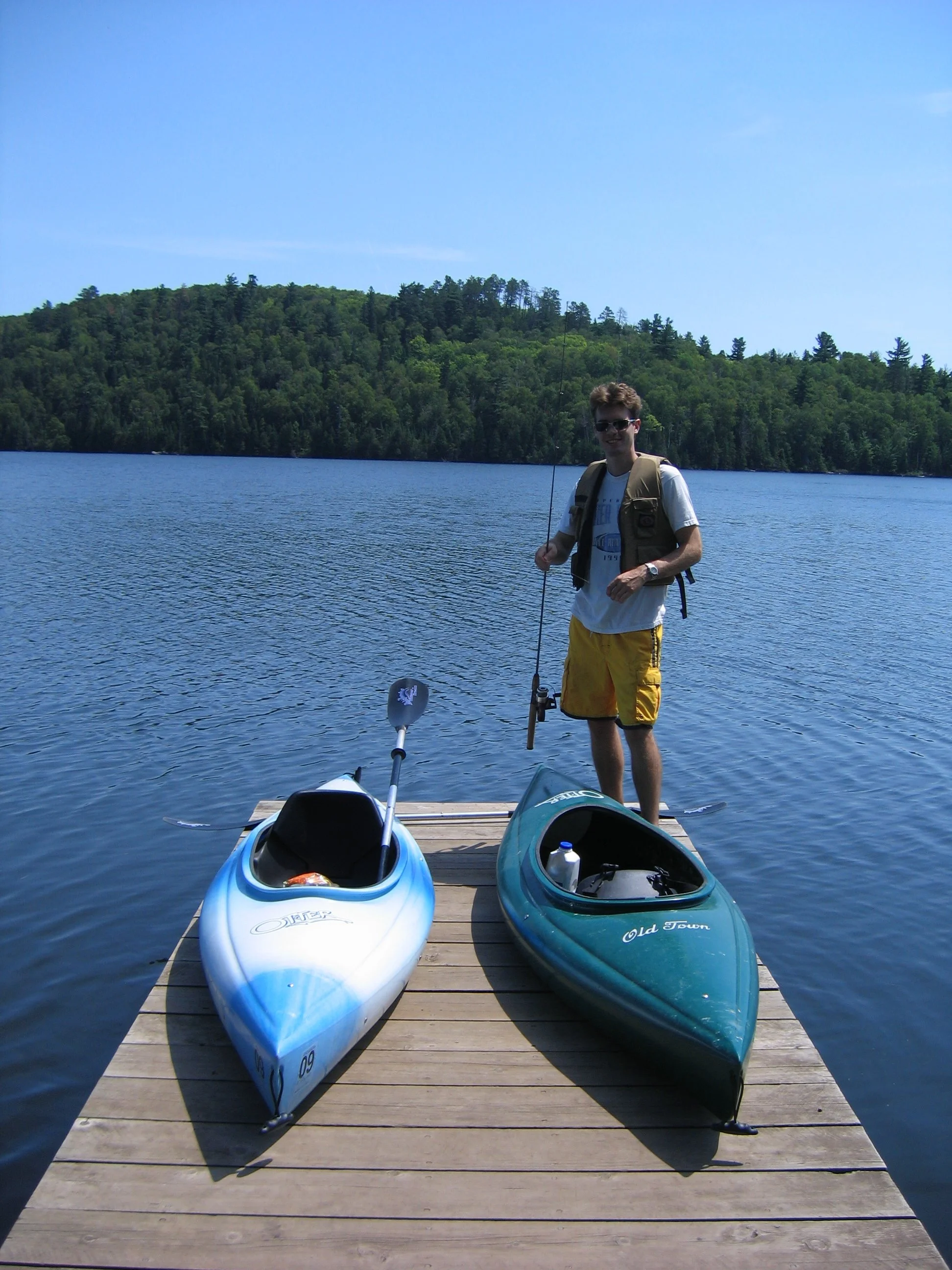
Our kayaks at Mic Mac Lake - we did have a lovely day kayaking here, even if the fish didn’t bite. But ask how to rent the kayaks that are already at Mic Mac Lake instead of portaging your own.
Mt Baldy
3.0 miles out-and-back (500 ft elevation) - this trail is marked in brown on my map.

View from Mt. Baldy

Mt Baldy is the brown trail
Mt. Baldy is a fantastic hike. It’s not hard, the views are incredible, and hardly anyone seems to know about it. Even on a Saturday of a peak fall colors, I had this trail to myself for the majority of my hike. If you have time for an extra hike, I would highly recommend Mt. Baldy.

Mt. Baldy Trailhead
Mt. Baldy starts out on the same road that I carried kayaks up 18 years prior (or my husband carried up his kayak, and then my kayak…) I chuckled to myself a lot reminiscing along this road that wisdom really does come with age.
At the top of the hill, the road keeps going to Mic Mac Lake, but there are trailheads along each side of the road. Left goes to Mt. Baldy, right goes to the trail surrounding Tettegouche Lake.
About a half mile from the road, after turning left onto the trail, you will see markers with letters. The letters correspond with points along the official State Park map. When you see the sign for F, turn again.

Turn at the F, and next look for the Mt. Baldy trail sign.
The branch up to Mt. Baldy is just a short way past the F. This is the trail that will take you up to the top of the mountain. One of the best parts about this trail is how gradual the elevation change is both up until this point, and the remainder of the climb. I though this was a very easy hike (but I wasn’t carrying a kayak this time…).

Trail marking the last ascent to Mt. Baldy
When you get to the top, there’s a T intersection. You will want to explore both sides. The trail from here is short in both directions and the views are both uniquely stunning. I love being up high when I can see so far. The best part of these views is that there is nothing man-made visible in any direction. Add in some fall color, and this is one of the pretties places I’ve ever been in my state.

View 1 from Mt. Baldy

Another view from the same rock I was standing on in the first picture. Trees as far as I could see.

Mt Baldy view 2 - This is the other trail from the T-intersection with overlooks of Mic Mac Lake
As I’ve already mentioned, don’t plan to take that tempting trail I marked in lime green. I reached the below swamp, lost the trail, and had to turn around and hike back uphill.

I lost the trail to Tettegouche Camp right after this swamp, and turned around
Tettegouche Lake
4.5 miles (830ft elevation)

The hiking loop around Tetegouche Lake is marked in aqua
I will confess that I have not done the entire loop around Tettegouce Lake. As I previously mentioned, I have been down the entire trail to Mic Mac Lake (black) and there are no views from above along this part of the trail; it’s all an old road. From where the aqua, black, and brown trails split, I’ve walked to the three main viewpoints marked on the State Park map. The views are not as good as they are from Mt. Baldy. The elevation is a little lower, and your views are obstructed by trees, as seen in the picture below, which was the best one out of all of the photos I took. I would recommend hiking Mt. Baldy, and skipping this trail around Tettegouche Lake.

View of Tettegouche Lake
Bear and Bean Lake Loop
Approximately 7.0 miles (900 ft elevation)

Bear Lake in front, Bean Lake in the back
This hike is highlighted in maroon at the bottom of the map.

Bear and Bean Lake Parking
I’ll start with the approximate mileage comment - the actual mileage depends on how far back on National Forest Hwy 11 you have to park from the trailhead. There is a large parking lot, but that was full when I hiked, and as seen from my GPS map shown below, I parked a ways back along that highway. This is one of the best hikes along the North Shore, and I think it’s the busiest trail I’ve ever hiked on along the North Shore.
One thing about this long hike that surprised me was there was no bathroom at the trailhead or along the trail, despite it being a longer hike. Just something to note so you are prepared.
Bear and Bean Lake Loop - using the GAIA app
The only negative thing about this hike was the sheer number of people on it. There wasn’t a moment where I didn’t see people ahead of me. The trail itself though was extremely fun to hike. So I guess my recommendation is to try this hike really early in the morning or later in the evening, and on a Monday through Thursday.

Bear and Bean Lake follows a portion of the Superior Hiking Trail
Similar to Mt. Trudee, the majority of the Bear and Bean Lake Loop hike follows the Superior Hiking Trail. These are the signs to watch for, until you complete the loop portion after Bear lake, in which case you’ll be looking for white signs.
Beginning of Bear and Bean Lake
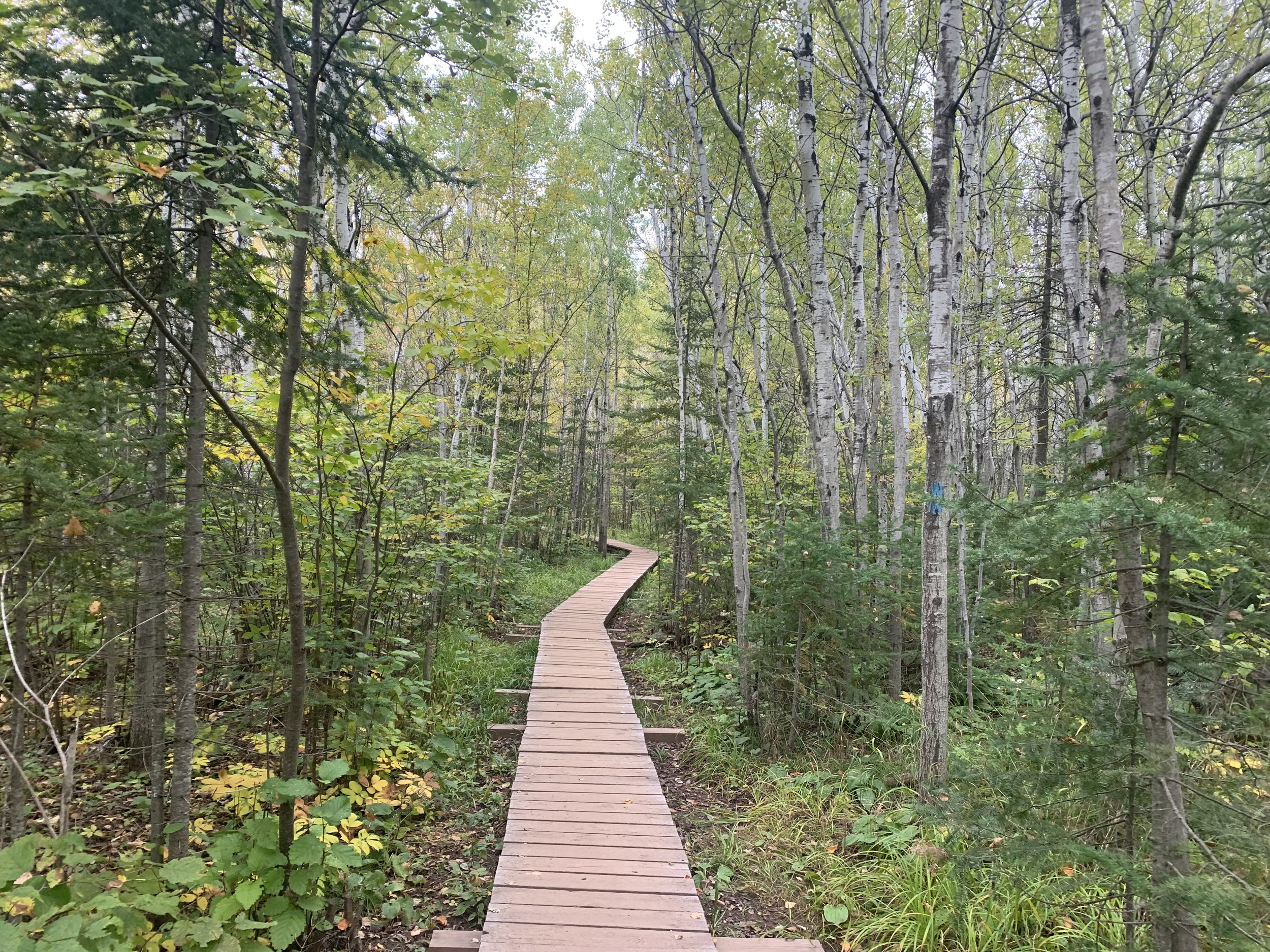
One of my favorite parts of this hike is how much the trail changes. There are parts where the trail uses board walks. Sometimes the trail climbs up and then follows directly on the rocks and the overlooks are incredible. Other times the trail descends along a dirt path through a forest. There are several ups and downs, like all great North Shore hikes. I don’t think there is an easier way to hike it one direction or the other. It’s pretty constant - up down, up down, up down.

Views from the trail - not quite as pretty as Mt. Baldy as you’ll see man-made water towers and other buildings, but there are lots of different views along the way.

Spur trail to waterfall
Unmarked on the state park trail, there is a small waterfall spur trail that can be explored. It’s about a tenth of a mile. The trail does go downhill though, so realize this is another climb up you will have to make to get back to the main trail. If you are interested in finding it, follow the signs to the Penn Creek campsite. It’s tucked on the left of the trail not quite all the way to the campsite. You’ll hear the water so no worries in trying to find it. Also, I’m sure there is a pit toilet in the campsite, but the campsite was occupied when I was down there, and I didn’t ask if I could use it.

Bean Lake
If you are walking clockwise as I did, this is the first view of Bean Lake. The first overlook was pretty crowded. Don’t wait here if it’s busy. Just keeping walking. There are plenty of places for pictures and the rest will not be as crowded.

Second view which includes more of Bean Lake
Below is the picture of both Bear and Bean Lake that I frequently see on the MN Hiking Pages on Facebook. The viewpoint is from the trail. Don’t fret about finding it. It will be obvious.

Bear Lake is in front, Bean Lake is in the back
Even after the trail turns away from the lakes there are still some great picture spots.

Bear Lake
I followed this hiking cat (below) for a bit, and it was so funny, I have to include a picture. Each time a dog would pass, the cat would slowly raise up on his owner’s back and her tail would fluff up a bit. The owner would pet her and she’d lay back down. I caught up to him and asked how he possibly kept his cat laying on his shoulders. His reply - she’s tired, she’d been hiking until recently. This was about 6.5 miles into the hike. I laughed for quite awhile about this. I should have asked the cat’s name. Seems like a hiking cat should be worthy of some sort of fame.

Black Beach
The hike out and back to Black Beach is about a half mile, depending on how far down the shoreline you go, and if you walk all the way out to the island, add another quarter of a mile. The elevation is obviously flat.

Black Beach off of MN-61
Black Beach is not included within the Tettegouche State Park boundaries, but it’s very close. To get there, search for “Black Beach” in GoogleMaps, or just turn on Lakeview Dr from MN-61, and drive about a mile. There is a place for the public to park just past the campground. There isn’t a formal trail, just wander along the shoreline of tiny black pebbles. My trek at Black Beach is shown in light blue.

Shoreline of Black Beach just south of Palisade Head and Tettegouche State Park

Black Beach
Black Beach is a quiet place to stop if you want to get close to Lake Superior. There are picnic tables available for use along the water.
As I said, there is no trail, you can wander as far as you’d like. I didn’t choose to go all the way out to the island, but I noticed that there were other people that had walked out there and were having fun exploring along the rocks.

Black Beach

I did see people climbing around on this island, so it is possible to walk all the way out there

Other Outdoor Things to Do within an Hour Drive
Below are hyperlinks to other posts I’ve written about things to do that are located within an hour’s drive from Jay Cooke State Park.
Split Rock Lighthouse State Park
(south) Pebble Beach is my favorite place to stop and play along the North Shore, and I think the best place in Minnesota to skip rocks. Little Two Harbors is the best short trail to see the lighthouse up close. Split Rock River is the best long trail with small waterfalls and views of Lake Superior. Day Hill is a shorter trail with views of Lake Superior.
Iona’s Beach
(south) This is a free beach on the Lake Superior shoreline, full of beautiful pink rocks.
Gooseberry Falls State Park
(south) Hike to three amazing waterfalls in 1.3 miles. Additional hikes included within the link.
Two Harbors, MN
(south) Not a hiking recommendation, but Betty’s Pies really is a fantastic place to stop for pie!
Canal Park
(south) Watch ships come in and out of the Duluth harbor while enjoying the aerial lift bridge raise and lower. There is also a light house to wander to.
Park Point Beach
(south) This is the only sandy beach I am aware of along Minnesota’s Lake Superior Shoreline.
George Crosby Manitou State Park
(northwest) This is a rustic, quiet, and less travelled MN State Park with one of the more impressive waterfalls in Minnesota.
Caribou Falls State Wayside
(north) An easy hike to large but quiet waterfall.
Sugarloaf Cove
(north) A privately owned section of Lake Superior with an interesting bay protected by rock formations. This park has a small fee and includes its own visitor center.
Sawbill Canoe Outfitter
(northwest) The closest entry to the Boundary Waters Canoe Area from MN-61 is Sawbill Lake. There is a canoe outfitter on the lake where canoes and other gear can be rented. There is a 4.5-mile three-lake trek for a single day exploration, and multiple options for multi-day canoe trips.
Temperance River State Park
(north) This is the most unique State Park along MN-61 where seven waterfalls can be seen in a hike less than 2 miles. Several of these waterfalls occur in dramatic pothole formations. The official MN State Park map undersells this state park, as does the size of the parking lot off of MN-61.
Oberg Mountain
(north) This is overlook hike is part of the Superior Hiking Trail, and therefore parking is free. This is a busier trail, especially in the fall.
Lutsen Ski Resort
(north) Lutsen is the best ski resort in Minnesota. During the summer months, the gondola continues to run. There are hiking trails and a half-mile Alpine Slide.
Cascade River State Park
(north) This park has multiple waterfalls that cascade, making it difficult to provide an actual waterfall count. Similar to Temperance, most of the waterfalls are within a hike less than a mile long. This is also the only MN State Park with a true hike along the Lake Superior Shoreline.
Eagle Mountain
The highest point in Minnesota can be accessed from the BWCA along a 6.5 mile out-and-back trail. This is an easy trail until the last 1/3 of the trail ascends 500ft dramatically. A permit is required, but it’s free, and the paperwork is available at the trailhead.
Grand Marias, MN
My favorite pizza along MN-61 is at Swen & Ole’s Pizza in Grand Marias.
Lake Walk - Superior Hiking Trail
The only section of the Superior Hiking Trail that is along Lake Superior’s shoreline is the Lake Walk, a 1.5 mile stretch of sand / loose gravel, just south of Judge Magney State Park. Note that this is an awesome beach, but a hard place to hike long distances due to the soft ground.
Link to Full North Shore Guide from NatureImpactsUs.com
For more ideas of things to do up and down MN-61 along Lake Superior, visit my North Shore Guide.
Other Hiking Ideas
If you are looking for more hiking suggestions, please check out my below map which has additional posts linked to each pin.