
View from Little Devils Tower - Custer State Park
If you enjoy my posts, please consider signing up below to get email notifications of my latest blogs. I will not share your email.

South Dakota’s Best State Park
With over 71,000 acres of protected land, Custer is South Dakota’s largest State Park, and currently ranks 8th in largest State Parks across the United States. I should preface that I have not been to all of South Dakota’s State Parks, but Custer has so much to offer in terms of beauty, activities, and wildlife, that I can’t imagine there could be a better SD State Park.
The most stunning hikes in the Black Hills are those in the Sylvan Lake area, which include a summit to Black Elk Peak and views from Little Devils Tower. Sunday Gulch is also accessible from these trailheads, and this trail is one of my favorite hikes in the United States. Sylvan Lake also includes a swimming beach and offers canoe / kayak rental.
There are also two main roads through Custer which are must sees.
Needles Highway is one of the most scenic highways in the country, and has incredible granite pillars. Granite hoodoos are special and rare due to the erosion-resistiveness of granite (wind, rain, ice, and gravity typically erode granite at a rate of ~1/10 of an inch per 1,000 years). These are the type of rock formations that I stare at and think “magic.”
The Wildlife Loop Road is the other place to visit within Custer State Park. Along this 18-mile road, there will be herds of bison, pronghorn, and deer. Burros will saunter up to car windows (and poke their heads inside if the windows are rolled down). Prairie dog towns are also scattered along throughout the drive.

Although the bison are wild and can wander anywhere they wish, it’s pretty common to find them while driving along the Wildlife Loop Road.
Custer State Park Logistics
Custer State Park is in South Dakota’s Black Hills. It’s located in the southwest corner of the state and is just a short distance away from of I90. It takes almost an hour to drive from Sylvan Lake to the Wildlife Station Visitor Center (on the southeast portion of the Wildlife Loop Road), so I’d recommend planning to spend at least a full day at the park for anyone that wants to hike in addition to driving Needles Highway and the Wildlife Loop Road. Avid hikers may need two days as both Sunday Gulch and the hike to Little Devil’s Tower / Black Elk Peak / Cathedral Spires are strenuous trails that I wouldn’t recommend combining into the same day.
Custer State Park does require an entry fee, and because it’s a State Park and not a National Park, the America the Beautiful Pass will not work. As of 2024, the entry fee for a car was $20 / day. Note that the Needles Highway (SD-87) will shutdown in winter months, as the road is not plowed. Access to Sylvan Lake remains open all year.

Family photo with my parents and my brother while hiking on a family reunion trip in the Black Hills
Lodging Options Near Custer State Park
There are multiple campground options both within Custer State Park as well as in the surrounding Black Hills and National Forests. For anyone looking for a hotel, Rapid City is the largest option with likely the most availability, as well as more restaurants and other stores than other nearby towns. The only downside to Rapid City is that the drive might be a little bit further. Rapid City would be my recommendation for anyone staying multiple days and exploring different sections within the Black Hills. We’ve stayed in several different hotels, as well as camped at the KOA. All have been quite comfortable. Rapid City has a population over 75,000, so this city should have anything that might be needed while on a vacation.
There are also several nearby towns which also have hotels. Custer is the closest to Custer State Park. The town of Keystone is another nearby option, although it’s closer to Mount Rushmore. Hill City is a little further to the north. Sturgis and Deadwood are towns about an hour even further to the north. Spearfish is a fun place to explore in the Black Hills, but this town is about 90 minutes from Custer State Park, and it’s not near any of the other places I would recommend visiting. I would instead simply suggest a day trip to Spearfish, but pick one of the more central cities/towns for lodging.

Downtown Keystone
Things To Do at Custer State Park
Below is a high-level map of Custer State Park. I’ve broken the park up into three different sections: Sylvan Lake, Needles Highway, and the Wildlife Loop Road. This is also the same order that I would recommend visiting them in a day. I prefer hiking in the morning, before it gets to warm, and Sylvan Lake has the best trailhead options. Canoes and kayaks are available for rent, and there is small beach for swimming at Sylvan Lake if it has warmed up enough to get wet after a hike.
Then drive down Needles Highway. Stop at the pullouts along the way to enjoy the view. There are also a few trailheads along the road. Note that this highway shuts down in the winter months due to snow.
As the sun gets lower and the day starts to cool off, drive down the Wildlife Loop Road. The animals are most active on a hot day in the cooler morning and dusk hours. Consider stopping at Mount Rushmore before the sun sets to watch the lighting ceremony.
Custer State Park is near several other parks that I would also recommend. For information on these parks, click on the following hyperlinks to additional posts that I’ve written: Mount Rushmore, Jewel Cave, Wind Cave, and Crazy Horse. I will list these links again at the end of this post.
The captions below the map are also hyperlinks, which can be used for quick navigation within this same post. Click on the section of Custer State Park that interests you, and the link will bring you to that section of the post with more pictures and information on what to do. There will also be a link back to this map at the end of each trail description. Or feel free to just read through the whole page.
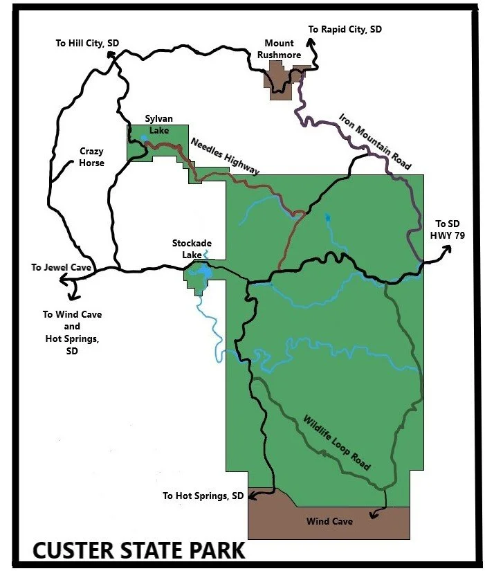
Sylvan Lake Trailheads - Multiple hiking options as well as a swimming beach with canoe and kayak rentals available
Needles Highway (SD-87) - Incredibly scenic drive past granite pillars (hoodoos). Note that this highway is closed during winter months
Wildlife Loop Road - This is a fun drive to find bison, pronghorn, deer, burros, and prairie dogs
Below is a more detailed view which includes trails and highway numbers. The X’s on the map indicate the approximate location where the Needles Highway is closed during winter months. For anyone traveling in fall or spring months, www.sd511.org provides current road conditions and closures. Just use the map on the link, zoom in, and click on SD-87 (between US 385 and US 16) to see if Needles Highway is open or closed.

Lakeshore Trail (red) - Easy 1.1 mile trail around Sylvan Lake. Scenic views from all sides of the trail.
Sunday Gulch (dark green) - Difficult but extremely fun 3.1 mile trail following several steps along a cascading stream and circling back through the mountains with amazing views
Black Elk Peak (orange + various route options) - Difficult trail out to the Black Elk Peak summit. The various route options include hikes 5.6 - 7 miles round trip.
Little Devil’s Tower (yellow + various route options) - Moderately difficult trail to stunning 360 degree views of the surrounding Black Hills mountains. An out-and-back hike is 2.6 miles, or add on as a 0.8 mile spur to hiking Black Elk Peak.
Needles Highway (SD-87)
Cathedral Spires (pink + various route options) - Moderately easy 2.3 mile trail to the base of tall rock spires
Sylvan Lake Trailheads
The main trailhead is just off the beach at Sylvan Lake. This trailhead allows for hikes along the lakeshore, which can also be used as a spur to get to Sunday Gulch. The same trailhead can be used to access both Black Elk Peak and Little Devils Tower.
When Needles Highway is open, there is a pullout which can be used to shorten the Sunday Gulch hike for anyone not wanting to add the Lakeshore Trail.
The shortest route to both Black Elk Peak and Little Devils Tower is from the Cathedral Spires trailhead. This trailhead can also be used for a shorter hike just to the base of the Cathedral Spires. The three trailheads are marked with black stars. Note that the Cathedral Spires Trailhead will be included within the Needles Highway section of this post.

Lakeshore Trail (red) - Easy trail around Sylvan Lake. Scenic views from all sides of the trail.
Sunday Gulch (dark green) - Difficult but extremely fun trail following several steps along a cascading stream and circling back through the mountains with amazing views
Black Elk Peak (orange + various route options) - Difficult trail out to the Black Elk Peak summit
Little Devil’s Tower (yellow + various route options) - Moderately difficult trail to stunning 360 degree views of the surrounding Black Hills mountains
Cathedral Spires (pink + various route options) - Moderately easy trail to the base of tall rock spires
Sylvan Lakeshore Trail
Distance / Elevation Gain - The Lake Shore Trail is a 1.1 mile loop with minimal change in elevation (marked in red below). There are a handful of steps at the midway point in the trail as it passes between the rocks.

Sylvan Lake Shore Trail (red) - Parking is marked with black stars
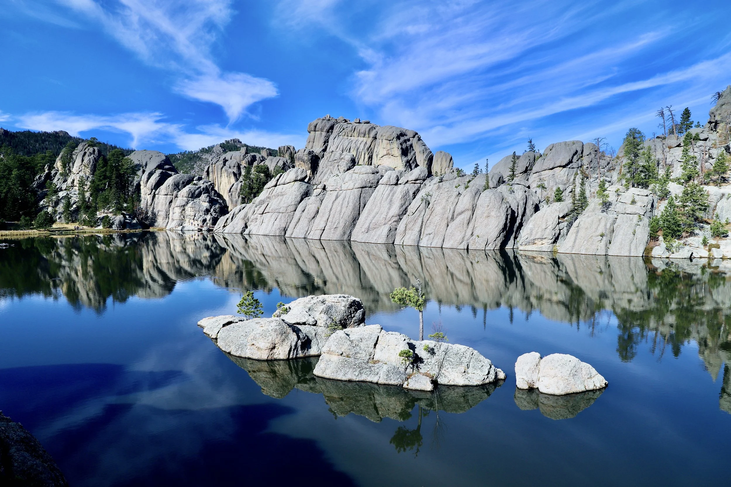
Sylvan Lake is absolutely stunning, surrounded by the mountains of the Black Hills. On a still day, there is an opportunity to take some amazing reflection pictures. The Lake Shore Trail is an easy hike for everyone, featuring views of Sylvan Lake from all sides of the trail. Non-motorized boats, such as canoes and kayaks, are also allowed on the lake, and can be rented from the Sylvan Lake Lodge.

Sylvan Lake viewed from the north-side of the trail
For more pictures and additional trail information, here is an additional post I’ve written: Sylvan Lakeshore Trail.
Sunday Gulch
Distance / Elevation Gain - The Sunday Gulch Trail is a 3.1 mile loop with an approximate gain of 700ft in elevation. The trail is marked in dark green below. If parking at the main Sylvan Lake trailhead, add 1.1 miles for the Sylvan Lakeshore Trail (marked in red). Additional parking is available on a pullout off of Needles Highway, and a trail loop without the Lakeshore is possible.

Sunday Gulch Trail (dark green) - Parking is marked with black stars
The Sunday Gulch Trail is strenuous, but also an extremely fun trail following several steps along a cascading stream which circles back through the mountains with amazing views. I’d put this trail in my 10 favorite hikes in the United States.
Sunday Gulch isn’t too long, but there are some steep sections. We hiked counter clockwise. This meant we hiked down the steep steps into the gulch, and when we hiked up it was along a dirt path with a decent amount of switchbacks. Usually my knees would suggest I hike up the steps rather than down, but the railings helped take some of the pressure off, and the steps are so steep, I can’t imagine how hard it would be to hike up them.

Steps leading down into the gulch
For more pictures and additional trail information, here is an additional post I’ve written: Sunday Gulch Trail.
Black Elk Peak (formerly Harney Peak)
Distance / Elevation Gain - The shortest option for hiking out-and-back to Black Elk Peak (formerly known as Harney Peak) is 5.6 miles (total) with an elevation gain of 1350ft. This option involves parking at the Cathedral Spires Trailhead and taking the purple to dark blue (Trail #3) to orange trails (and following the same route back).
The loop hike version, starting at the main Sylvan Lake Trailhead, and following gray (Trail #4) to dark blue (Trail #3) to orange to light blue (Trail #9), is approximately 7 miles with an elevation gain of 1360ft.

Black Elk Peak is marked in the upper righthand portion of the map with the orange trail indicating the final ascent. Parking is marked with black stars. There are multiple route options.
The goal of hiking Black Elk peak is to get to the stone observation tower at the top. This stone structure is open, and can be entered. I’d suggest the shorter out-and-back from Cathedral Spires (in non-winter months when Needles Highway is open), and I would also suggest adding the spur trail to Little Devil’s Tower.

Observation Tower at Black Elk Peak - viewed from Little Devil’s Tower
Black Elk Peak is touted as the “highest point east of the Rocky Mountains and west of the Pyrenees Mountains in France”. I was just out hiking in Texas though, and Guadalupe Peak is both higher than Black Elk Peak…. Unless there is an argument that Guadalupe Peak is in the Rocky Mountains, which seems to be a stretch, I’m not sure I agree with South Dakota’s topography claim. It’s still a great hike though.
The below picture is a unique view of Mount Rushmore. The mountains on the left in the middle are the backside of “Six Grandfathers” mountain. The faces are carved into the opposite site, so they are not visible from Black Elk Peak.

View of the backside of Mount Rushmore from Black Elk Peak

View of Cathedral Spires from Black Elk Peak
For more pictures and additional trail information, here is an additional post I’ve written: Black Elk Peak.
Little Devil’s Tower
Distance / Elevation Gain - The hike up to Little Devil’s Tower is marked in yellow. Tacking the yellow trail onto the hike to Black Elk Peak adds 0.8 miles (total) with an elevation gain of 200ft.
A specific hike to Little Devil’s Tower from the Cathedral Spires Trailhead (purple to yellow and back) is 2.6 miles total, with an elevation gain of 750ft.
Starting at the main Slyvan Lake Trailhead (gray to yellow and back) is 3.7 miles total with an elevation gain of 850ft.

Little Devil’s Tower is marked in the upper righthand portion of the map, with the yellow trail indicating the ascent. Parking is marked with black stars. There are multiple route options.
I think the view from Little Devil’s Tower is better than Black Elk Peak, mainly because the Cathedral Spires rock peaks are closer, but also because the fire tower on Black Elk Peak is visible. The trail to Little Devil’s Tower is shorter and less elevation than Black Elk Peak, but it requires some rock scrambling to get to the top, versus the hike up to Black Elk Peak is more of a formal trail the whole way up. Ideally, check out both views, since the spur to Little Devil’s Tower only adds 0.8 miles.

View of Cathedral Spires from Black Elk Peak
For more pictures and additional trail information, here is an additional post I’ve written: Little Devil’s Tower
Needles Highway
SD-87 (also known as Needles Highway) is closed in the winter months from first snow until the ice melts (typically somewhere between March and April). The map below highlighting the approximate road closure. Although this highway closes to cars in the winter, the road can still be used throughout the winter months for hiking, snowshoeing, and/or cross-country skiing.

Needles Highway SD-87 - X’s mark where the highway is closed in the winter months. Black stars mark the parking area for trailheads. The blue star marks the Needles Eye Tunnel. There is a pullout for a small number of cars to park here. The rock formation, Needles Eye, is less than 200ft west of the tunnel.
Needles Highway, SD-87 between US 385 and US 16, is one of the prettiest drives in the United States. Be warned though, similar to other scenic highways, this road comes with steep elevation gains and losses and tight curves.
Near the Needles Eye Tunnel, there is a small pullout that can be used for parking. From this parking area, one can get great pictures of the tunnel as well as the rock formation known as Needles Eye.

Approaching Needles Eye along SD-87, traveling west-to-east
This is a fun spot to drive through, and it is possible to take pictures from the car, but these rocks are incredible, and to fully appreciate them, I think it’s worth stopping a moment.
When travelling east-to-west, Needles Eye is just before the tunnel. Both can be easily walked to from the same pullout area.

Needles Eye
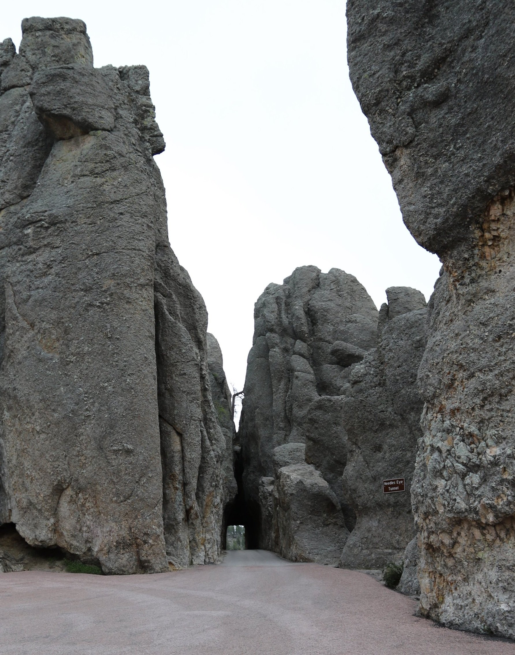
Needles Eye Tunnel (approaching west-to-east)

Same tunnel, as viewed from the car

Tunnel viewed east-to-west
Cathedral Spires
The Cathedral Spires trailhead is about 1 mile east of Needles Eye.
Distance / Elevation Gain - The hikes to viewpoints in the Cathedral Spires are marked in pink. The shortest trail to Cathedral Spires is 2.34 miles (total) with 1,075ft in elevation gain. This route involves parking at the Cathedral Spires Trailhead (purple to pink and back).
Adding the Cathedral Spires to a hike to Little Devil’s Tower or Black Elk Peak adds approximately 0.8 miles with another 350ft in elevation gain.

Map of the Cathedral Spires Trailhead
Between Needles Eye the Cathedral Spires trailhead, there are a handful of places to pull over and park. I think these are fantastic places to stop and appreciate the incredible rock formations in a slower manner than simply driving straight through.

This pullout is just east of the tunnel. Zoom in near Chris’s left knee to see the tunnel through the rock.
The Cathedral Spires Trailhead offers a shorter hike to just the base of the spire rocks, and as I’ve mentioned above, this trailhead offers the shortest distance to reach both Black Elk Peak and Little Devils Tower.

Cathedral Spires - from Needles Highway

Always frustrating when the weather doesn’t work out to be perfect for photos. I may have been grumbling about the clouds prior to taking this - but it did end up being a perfectly placed low-hanging cloud…
The trail to Cathedral Spires is full of these rock formations (hoodoos). All of the hikes are amazing along Needles Highway (including the trailheads at Sylvan Lake). I would encourage everyone to pick at least one trail to become immersed for at least a short moment in this scenery.

Hoodoos along the Cathedral Spires trail
When we hiked along this trail in the middle of October, we came across a mama mountain goat and her kid.

Mountain goats just off of the Cathedral Spires trail
Cathedral Spire rock formation is easily seen from both Black Elk Peak and Little Devils Tower (view pictures above). This photo is from the base looking up at the same formation.

Base of the Cathedral Spires
Wildlife Loop Road
The Wildlife Loop Road is an 18-mile road through open grassland at the southern end of Custer State Park. The maximum speed limit is 25 mph, and both wildlife crossing the road and people in cars taking pictures are going to slow that speed down even further. If a small herd of bison cross the road, it’s going to take a bit of patience. Get out the camera, and expect the drive could take 1.5-2 hours.
What’s the best time of day to drive this loop? The formal answer is anytime, it’s not like the animals hide at any particular time of day. But on a hot summer day, while you may be appreciated the air conditioned cars, the animals are going to be hot, likely trying to stay in the shade, and are probably going to be less active. In the summer months, my suggestion would be to go either in the early morning, or an hour or two before sunset.
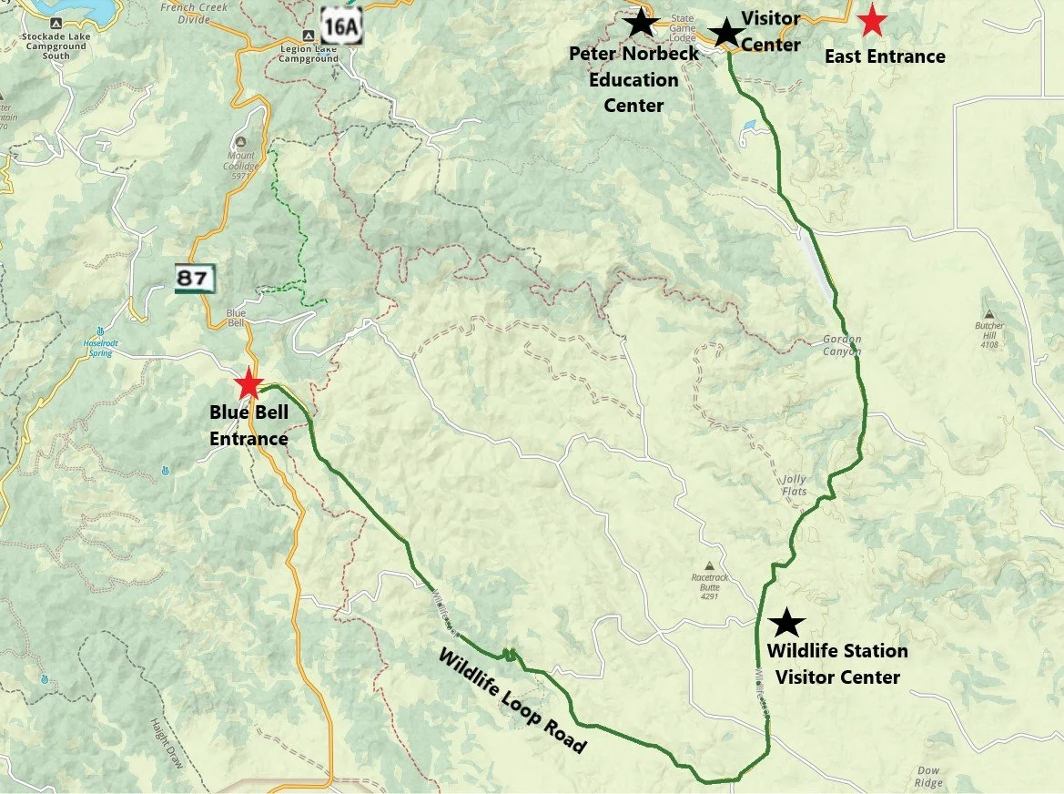
Map of Wildlife Loop Road in Custer State Park
There are a few places along the Wildlife Loop Road to park and hike, and we’ve done a few of these trails, but you should see plenty of animals just from the car, and I haven’t found any trails that I think are phenomenal. My recommendation would be to enjoy the car ride, and for hiking, head up to Needles Highway and/or Sylvan Lake.
While on the Wildlife Loop, expect to see bison, burros, pronghorns, and prairie dogs. Less frequently we have seen mule deer. Supposedly the park also has elk and coyote, but these have eluded us thus far.
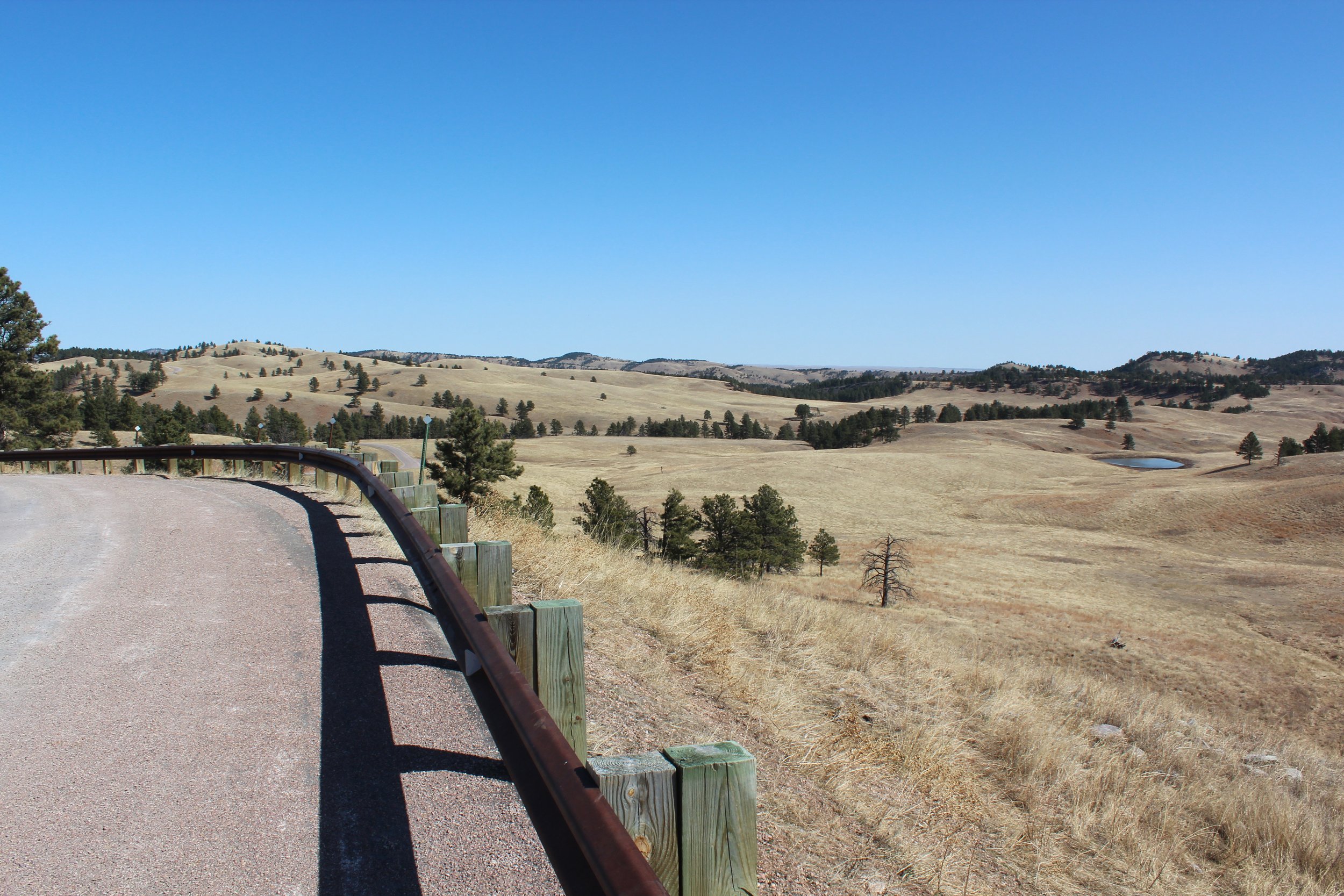
Open grasslands along the Wildlife Loop Road in Custer State Park
The primary habitat that the Wildlife Loop Road travels through is open grasslands along gentle rolling hills. Because of the sparse pine trees, it’s easy to gaze out into the open land and see bison and pronghorns.

Wildlife should not be approached. These are wild animals. The safest spot for both you and the animals is to remain in your car.

Small herd of bison crossing Wildlife Loop Road in Custer State Park
Again, it seems like this should be obvious, but every once in awhile someone ends up in the news… Stay in the car - don’t approach the bison. I prefer viewing the bison from afar, but on multiple occasions along this road, they do end up crossing the road in front of us. Just be patient, let them pass, and take pictures from inside the car.

Burro along Wildlife Loop Road
The burros along Wildlife Loop Road are a bit of another story… Not only will they cross the road, they will stick their head right into cars. They are looking for hand outs. Please don’t feed them.

Lots of pictures of burros - they are my favorite part of the Wildlife Loop Road
Here is what it looks like when a burro says “hi.” If this is too close, just close your window to keep them out. I like getting to pet their noses.
The burros are also wild, but they are in Custer State Park due to their ancestors who worked on Mount Rushmore. After the monument construction was complete, the remaining burros were released into the wild, in what is now Custer State Park. They have continued to flourish here for generations.

These burros are quite sweet. Again, stay in your car - but they seem to like their noses being petted.
Pronghorn are another favorite of mine along the Wildlife Loop Road. Usually we see them a ways up on the hills, but this one wandered right down to the road.

Pronghorn along the Wildlife Loop Road
Bison are pretty common along the Wildlife Loop Road. While they are wild and can roam wherever they’d like within the park, their population is managed. Once a year, at the end of September, all bison (approximately 1,300 animals) are roundup. 200-500 animals are selected to be sold (this keeps the population numbers at a healthy level). Cows are checked to identify which ones are pregnant. Animals born earlier in the year are branded and vaccinated.

Bison scratching an itch on the bark of tree along the Wildlife Loop Road

The well-placed bison in front of signs make me laugh. We have another great picture of a bison in front of the Badlands Entrance sign.
There are several different kinds of birds that may be visible within the park as well. Below are some turkeys that we found one year. I’ll be honest though, the hooved animals distract me pretty well along this drive, and often I forget to keep an eye out for birds.

Turkeys along the Wildlife Loop Road
Other Nearby Things To Do
There are several other things to do in the Black Hills, and this place in South Dakota is one of my favorite vacation spots. It’s easy to enjoy an entire week here. Below are additional posts I’ve written on places to explore within the Black Hills.
Visiting Mount Rushmore
Explore Waterfalls along Spearfish Canyon
Hike Around Devils Tower National Monument
Tour Jewel Cave National Monument
Tour Wind Cave National Park
Exploring Badlands National Park
Visit Minute Missile National Historic Site
Swim at Hippie Hole
More from NatureImpactsUs.com
To see additional hikes that I’ve written about around the country, click on a pin, and then click on the hyperlink. Use two fingers to zoom in and move around within the map.