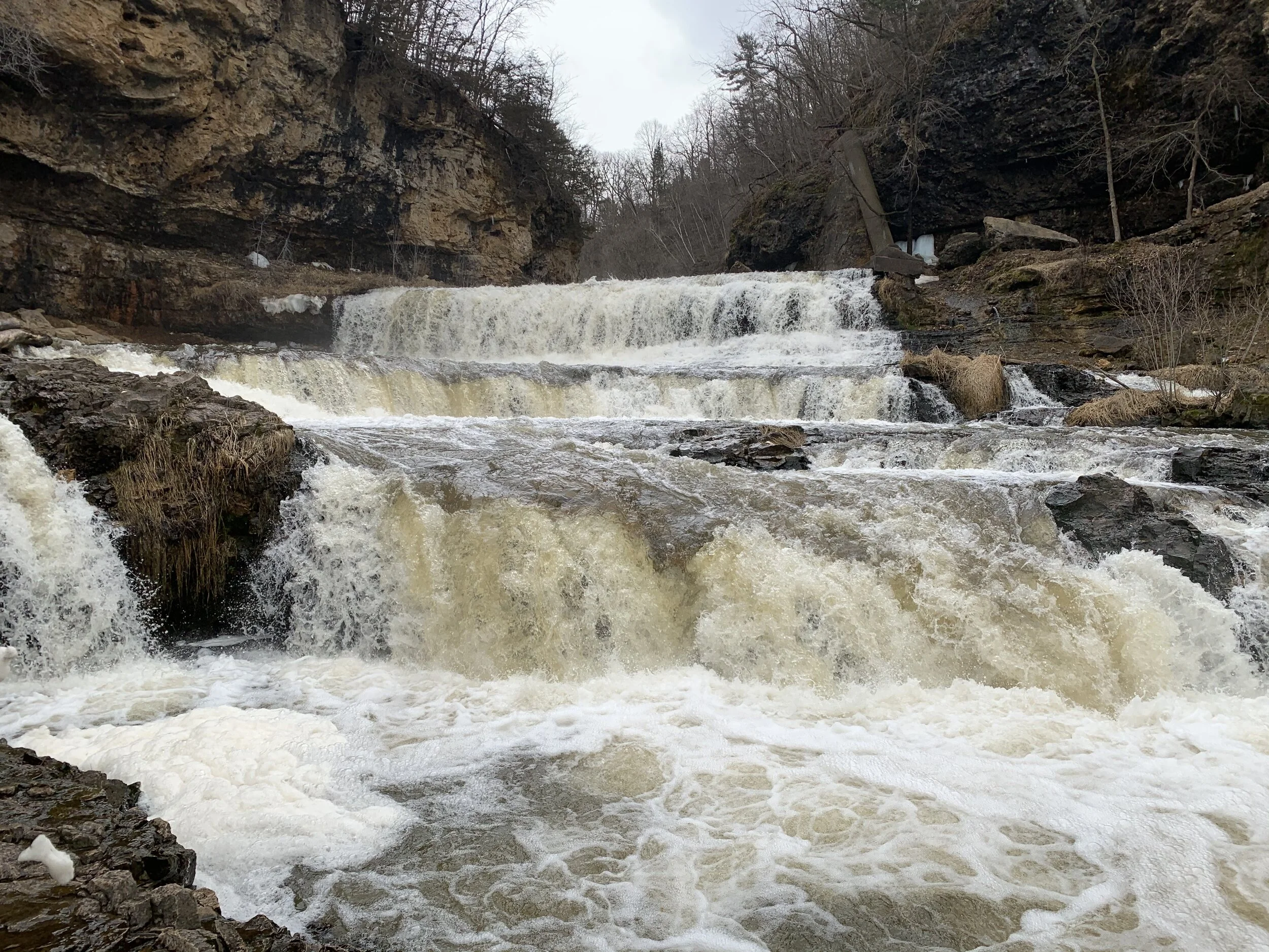

Willow Falls at Willow River State Park - Wisconsin
If you enjoy my posts, please consider signing up below to get email notifications of my latest posts. I will not share your email.
Finding the Perfect Waterfall
Have you watched a baby drop things over and over and over again, simply fascinated that whatever they let go of, ends up on the floor? I feel the same way when I stare at a waterfall, simply fascinated that as I’m watching the waterfall it doesn’t run out of water. I can stare for quite awhile, but the water just keeps coming. It’s that sense of wonder that has me hiking to waterfall after waterfall. And one of the great things about living in the Twin Cities is that there are lots of waterfalls within a short driving distance of Minneapolis and St. Paul, MN. Minnehaha Falls, Shadow Falls, Hidden Falls, Vermillion Falls, Wilke Glen and Cascade Falls, Big Spring Falls, Wolf Creek Falls, etc. I think the most impressive waterfall within this area is Willow Falls, within Willow River State Park. This waterfall is just over the border in Hudson, WI. There are rocks for your kids to climb and get right up close to the waterfall, as well as a bridge crossing over the river to allow for that perfect picture.

Willow Falls in the middle of March
Planning Your Trip
Reference the below interactive map for great places to hike within 2 hours of Minneapolis and Saint Paul, MN. Use two fingers on the map to zoom in and look around. Check out my other posts to find additional blogs of these hiking locations.
Location and Entrance
There are two parking lots for Willow Falls. I’ve circled them in the below map from Wisconsin’s DNR website. These two parking lots are pinned in the above GoogleMaps page. To search for these parking lots in GoogleMaps, use “Willow Falls Parking Lot” and “Burkhardt Trail Head”. In the below map, the River Road Parking Lot is the same as the Burkhardt Trail Head.

Willow Falls Map - Edited from Wisconsin’s DNR
Time Needed and Other Things to Know
Give yourself about an hour to walk down to the falls and spend some time enjoying them. If you intend on hiking some additional trails, plan 2-3 hours.
Willow River is a Wisconsin State Park. Your MN State Park decal will not work here. You can stop at the park office to self register a day or annual pass. The park office is also circled on the above map.
If you are traveling in the winter or early spring, bring hiking poles or Yaktrax as the trail can be slippery.
Hikes at Willow River State Park
Willow Falls Trail
The trail from the Willow Falls Parking Lot to Willow Falls is 0.6 miles (one way). The trail is short but steep. In the winter and early spring, the trail is covered in snow and ice and it is slippery. Consider bringing something to help with stability, like hiking poles or increase your traction with YakTrax.

The first split you will come to in the trail is to the North Overlook. This portion of the trail is highlighted in bolded yellow in the above map. From the split to the overlook is 0.25 miles one way.

View from North Overlook
If you take a left at the second split in the trail, it will take you to Little Falls Lake. Stay to the right and follow the sign to the falls.
There will be a bridge over the river that you need to cross to get the best views of the falls. In the age of COVID, the bridge may be crowded, so either bring a mask or wait until it’s less crowded.

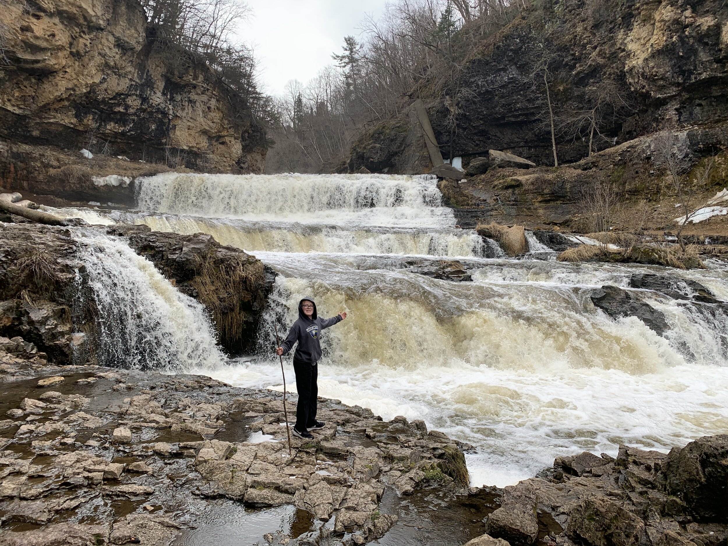
Playing on the rocks at Willow Falls
Once you are over the bridge, you can explore and get right up next to the falls. And there are rocks on this side of the bridge. If you have kids, this is a great spot to let them climb and play.

Rocks at the bottom of Willow Falls

Climbing the rocks at the bottom of Willow Falls
Burkhardt Trail
If you are looking for a safer plan to get to Willow Falls in the icy parts of spring, the Burkhardt trail is only slightly longer than the Willow Falls Trail (1 mile from the parking lot to the falls). This trail head takes off from the River Road Parking Lot (as labeled on Wisconsin’s DNR map). Note that there are 244 steps on this hike, but there are railings for the majority of these steps.

Steps from the bottom of Willow Falls leading to the Burkhardt Trail

More steps - but this was much easier to hike on in the spring than the Willow Falls Trail
The Burkhardt Trail also has a 0.5 mile loop (I shaded this in maroon on the above map). If you came in on the Willow Falls Trail and want to extend your hike a little longer, head up the stairs after the falls, and take a right at the top to head around the loop. There are really pretty views of the Willow River along this loop.

Views of Willow River from the Burkhardt Trail
More from www.NatureImpactsUs.com
There are posts linked to each pin below.