
Observation deck at Carley State Park
If you enjoy my blog, please consider signing up below to get email notifications of my latest posts. I will not share your email.

Calm from the Storm
My first time to Carley State Park was back in March 2020, on the day Governor Walz announced the state was shutting down due to COVID. I was in Rochester with my two boys, pretending to have some fun during their Spring Break since we’d canceled our trip out to California. It was cold and raining. I didn’t know what a shutdown meant, or how possibly to prepare for it, so we just kept walking in the rain because I had no idea what else to do as I tried to make sense of my new world. I wonder how many others find themselves in the same state of mind at Carley State Park, just 30 minutes from Mayo Clinic in Rochester, MN. As hiking is so therapeutic, I have to imagine some people find themselves in Carley walking the same trails, while trying to adjust to a new diagnosis.
Carley is a small park without even a visitor center, which makes it the perfect place to step clearly out of society and to just be. Whatever that might mean for yourself. Carley likely isn’t a destination for many tourists, except those trying to hike the MN Hiking Club trail in every state park, but that’s part of it’s charm of being a secret. I’s a beautiful and calming park for those nearby to enjoy in peace with relatively easy trails. Carley also has White Pines, which are uncommon in this part of the state due to earlier logging. Several trails are covered in pine needles, which feels more similar to hiking in northern Minnesota.

March 25, 2020 at Carley State Park
Planning Your Trip
Carley is just 30 minutes east of Rochester, MN. It also sits 15 minutes from Whitewater State Park. Unlike Whitewater, Carley is small. You can hike the majority of the park in less than 3 miles, so a trip here can be easily be 2 hours or less.
To pay for a day pass to park, if you don’t have an annual MN State Park Pass, there will be a place to stop your car and fill out an envelope that will take cash, a check, or a credit card number. You’ll leave the pay stub from the envelop on your dashboard, and there is a locked box to slip the envelope into.

North Branch of Whitewater River flowing through Carley State Park
See the below interactive map for additional places to hike in Minnesota and neighboring states. Use two fingers on the map to zoom in and look around. Links to blog posts for each pin are included.
Time Needed and Other Things to Know
Carley is a small state park, so a trip here can feel complete in about 2 hours. There is a picnic pavilion, but keep scrolling through my post to see a better table to enjoy a picnic lunch.

A covered picnic pavilion is available, but there is a secluded table to the right of this picture and down a ways along the river.
The trails are pretty easy here, but if mobility is a concern, it might be good for you to know there are steps on the trails to get down to the river, and in order to cross the river, similar to Whitewater State Park, there are stones you will need to walk across. If you come in the spring when the snow is melting or after a heavy rainfall, these river crossings might not be possible.

In March, we were not comfortable crossing this river due to some stones being covered with water and not knowing how slippery they might be
Location and Parking Lots
This is an easy park to navigate because it is so small. There are three parking lots, even though only two are marked on the map. The third is where the monument symbol is at the bottom of the map when you first enter the park. There is also a pit toilet at this parking lot. If you are looking to hike the majority of the park, I would park at the red dot on the below map. If you have limited mobility and are just interested in hiking in the flat portion of the park along the river, then park near the picnic pavilion at the blue dot on the map below, and follow the blue-marked trail/road.

Note that I’ve added both colors and letters to the state park map so I can refer to these places in my post, and they are not present at the park themselves
Hiking at Carley State Park
I’m going to show you around the park following what I’ve labeled as the purple trail in the above map, starting at the parking lot with the red dot, and crossing the river right away when you get to the bottom of the hill. This trail is about 3 miles.
Pretty quickly in the trail, you will come across steps to get down to the river. These are the same steps shown in the second picture within this post (viewed from the bottom and looking up). This is approximately the point at which I’ve labeled as “A” on the map. You can see the Whitewater River below - this is the North Branch of the Whitewater River which flows through Carley. You will need to cross the river on two bridges when you get to the bottom of the hill.

Steps down to the Whitewater River
Throughout Carley, you will notice interpretive signs with information about the park history and the habitats you walk through. The signs are a bit older and need to be replaced, but I would take a look at the ones you can still read as the information is quite interesting.

Interpretive signs throughout Carley along the trails
At the bottom of the hill, to cross the river, you will need to walk across two sets of stone “bridges” assuming the water is low enough for you to safely cross over stone to stone.

First bridge at the “B” label on the map

First bridge at the “B” label on the map

Second bridge at the “B” label on the map
After crossing the river, you will walk up a small hill, at approximately the “C” label on the map.

Trail leading to the bluff above the river
You will maintain this elevation once you are up the hill, until you get the split in the trail. There isn’t much walking up and down along the trail, which makes it an easier park to hike than nearby Whitewater State Park.

Trail along the bluffs overlooking the river below
At the trail split, near “D” on the map, I would recommend picking the northern trail if you want to see a different part of the park, and follow the trail I have marked as purple. If you choose the other path, there are more white pine trees, which is nice, but the trail continues to follow along bluff above the river, and the scenery doesn’t change too much.
Taking the north route at the trail splits leads to a forest that is less dense, and a ravine with a small tunnel that I am assuming is for water management.

Northern trail at Carley

Interesting ravine with a tunnel / bridge

North route at Carley
This route does pass by private property and there are trails on the private property section, so watch for the signs to make sure you stay within the park.

Northeast side of the park borders privately owned property

Carley State Park
The trail will descend again and then cross back over the river (marked “E” on the M). You can see some nice white pines ahead in the picture after crossing the river.

Bridge across the eastern portion of Whitewater River

Whitewater River
The trail will ascend quite slowly past the river through a section of older and taller trees.

Carley State Park
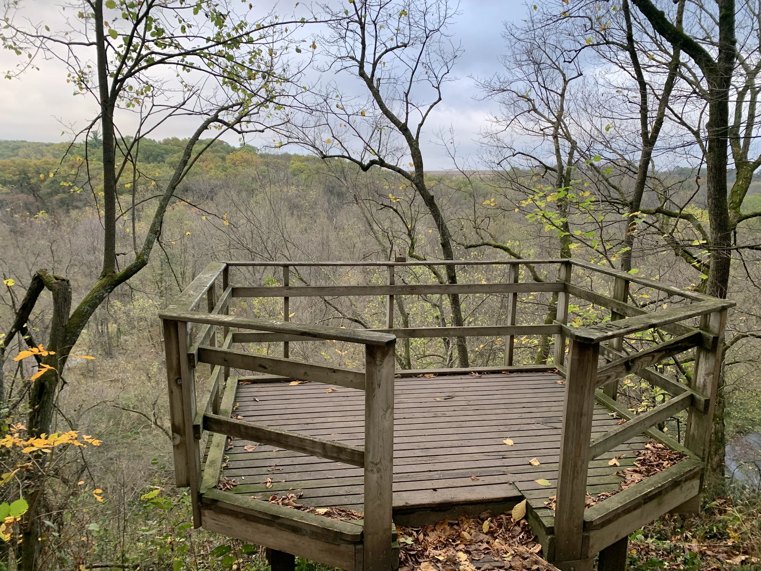
Loosely labeled “F” on my map, you will see a cool observation platform overlooking the river.

Observation platform at Carley State Park

Closer look at the observation platform

View of the river from the observation platform
The trail is pretty flat here, and wooded by more white pines.

Carley State Park

Carley State Park
About where I have “G” marked on the map is another set of steps to get back down to the river.

Carley State Park
At the bottom of the steps, the trail opens up in a grassier section.

Carley State Park
It’s a slightly awkward shaped trail, so if you stay on the purple route, you will see the next river crossing, but you won’t actually cross here. You will continue on the trail on the same side of the river.

River crossing labeled “H” on the above map

Same bridge as above
This part of the trail is flat and grassy, and it follows closely next to the river. Looking back you can see that same bridge. At this point, the picnic pavilion will be on your left and the river on your right. If you’d like to find a place for a snack before getting back to your car, at about the bend in the river I have marked as “J” you will see a picnic table secluded from the rest of the picnic area. This is the best placed table in the park, and would be a great place to stop for a bit if you are hiking with kids to let them play for a bit in or next to the water.

Picnic table near “J” on the map (though on the same side of the river as the trail)
There are a few benches to stop at and enjoy the view.

Whitewater River at Carley State Park
Following along the river, the trail stays like this picture - flat and grassy and continues close to the water.

Picture near “K” on the map.

Carley State Park
That’s the loop. You’ll end near this bench, and head back up the steps to your car.

Carley State Park
Other Things to Do Nearby
Whitewater State Park is my favorite non-North Shore State Park, and it is only 15 minutes away from Carley. If you have another day to hike, this is a great place to head to. See the below post for more information:
If you are staying in Rochester, a local hiking area to check out is Quarry Hill.
More from www.NatureImpactsUs.com
Posts are linked to each pin below.