
Mesquite Dunes in Death Valley National Park
If you enjoy my blog, please consider signing up below to get notifications of my latest posts. I will not share your email address.

Why is it called Death Valley?
So, you’re considering a trip to Death Valley National Park. You probably know that it has the hottest temperature recorded on the planet, and that it has the lowest elevation in the United States. You may not know much more and perhaps you do not find its name, Death Valley, to be very inspiring. In fact, its name may give you a reason to worry about visiting this park. So, let’s start with the “why” behind the park name, to get that out of the way.
Death Valley was given its name by a group of people that got lost in the area during the winter of 1849-1850. According to the National Park Service, it is thought that only person out of this group actually died, but as the party was being rescued and on their way out through mountains, someone turned around and said “Goodbye Death Valley” - and the name stuck.

Devil’s Golf Course
Despite having the name Death Valley, there are several plants, animals, and people that have made Death Valley their home. There’s even a special fish, the Pupfish, that lives in Death Valley. You can see these fish along the Salt Creek trail. These plants and animals have special adaptations to withstand the extreme heat and lack of drinking water.
Keep in mind that you do not have these same adaptations. You are made of about 60% water. When you go out in the dry heat you will lose water quickly. In the summer months in Death Valley, you will need to drink about a gallon of water to replace the water you lose. This is something to consider every time you get out of your car. If you are a family of 4, this means you should have about four gallons of water in your backpack. That’s crazy heavy. Logistically, this means you should visit Death Valley over winter or spring break instead of summer vacation. Summer is hot - it’s just not necessary to see if an egg can fry on the sidewalk. It can… Plus a trip in the summer is primarily just driving from one viewpoint to another. If you can’t get out and hike, you are missing the best parts of the park.
Even visiting in March, it was 85F when we were there. Carry 2L of water per person when you hike, remember to eat salty foods, and use sunscreen. The trails do not offer much if any shade. Those warnings aside, I hope my pictures do inspire you to visit this amazing park.

Badlands Loop
Planning Your Trip
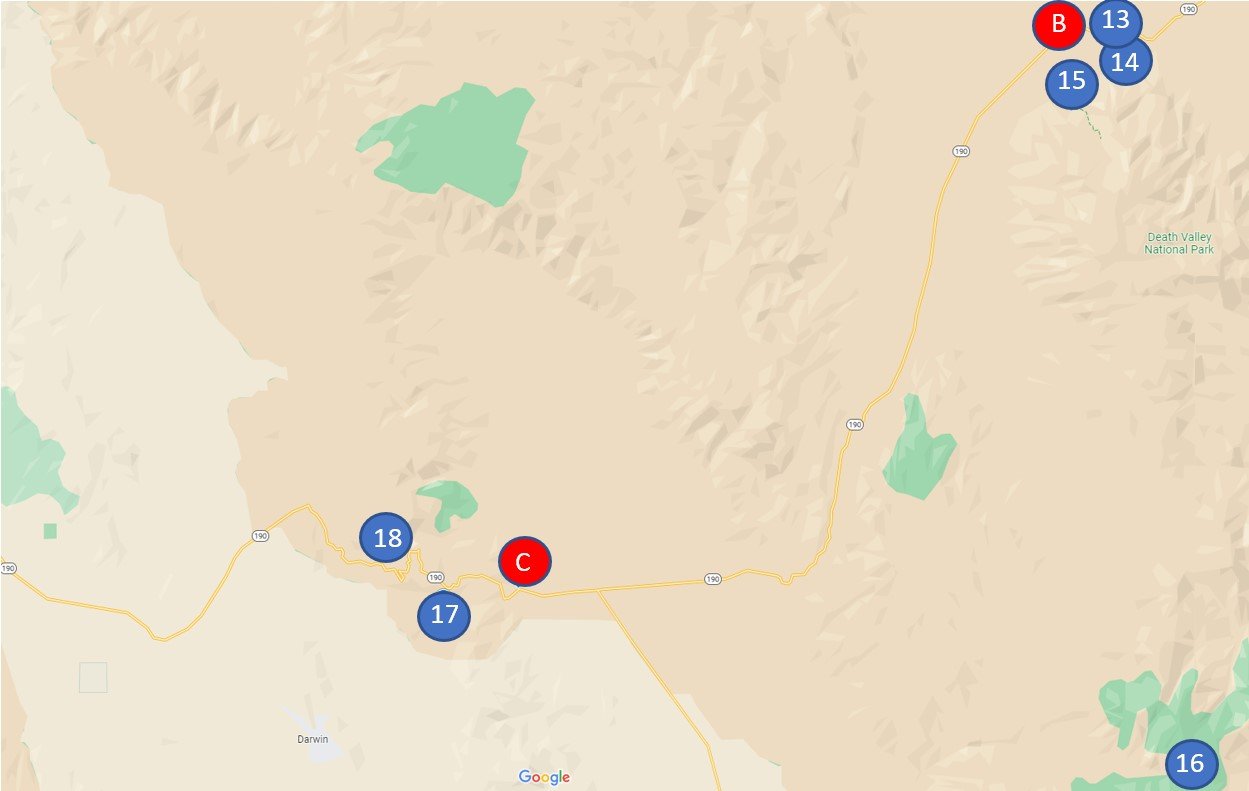
Reference the below interactive map for Death Valley National Park visitor centers, trailhead locations, lodging, and other nearby activities. Use two fingers on the map to zoom in and look around.
Nearest Large Cities with Airports
Death Valley is on the eastern edge of California, and the closest major city is Las Vegas with about a two-and-a-half-hour drive. Los Angeles is a little over four hours away and is the second closest large city. When we visited Death Valley, we flew in and out of Las Vegas. After visiting Death Valley, we drove to LA and then San Diego before heading back to Vegas.
Lodging Options
Within Death Valley National Park, lodging is limited. There are 8 campgrounds. All but two are only open October through April, and Furnace Creek is the only campground you can make reservations at. The reason the majority of the campgrounds close mid April through mid October is due to the heat.
There are a small number of hotels within Death Valley. At Furnace Creek there is the Inn at Death Valley and the Ranch at Death Valley. At Stovepipe Wells there is the Stovepipe Wells Village, and at Panamint Springs there is the Panamint Springs Resort.
Outside of the park, there are three very small towns with limited lodging options. Shoshone (in California) is on the southern end of the park. It is about an hour drive to the Furnace Creek Visitor Center. Amargosa Valley (in Nevada) is about 45 minutes to the Visitor Center, and Beatty (also in Nevada) is approximately a 50 minute drive. We stayed in Amargosa Valley at the Longstreet Inn, and it was a nice hotel. It’s in Nevada, so of course it has a casino in the lobby, but the hotel was clean, the grounds were really pretty, and they had a nice restaurant with live music on the weekend.
Entrances

Salsberry Pass
The popular entrance to Death Valley, if you are travelling from Las Vegas, is along 190 (near Amargosa Valley). When you enter the park, you’ll be near Dante’s View and Zabriskie Point. There is a lesser traveled southeastern entrance that does not add any extra time if travelling from Las Vegas, near Shoshone. This will take you into the park through the Salsberry Pass along 178, which is beautiful. Most likely, you won’t be travelling this far south in Death Valley to see any particular trailhead or special site, so if you are driving in from Las Vegas, this is the entrance I would recommend. It’ll be your only time to see Salsberry Pass and doing it on your way into the park won’t add any extra time. Just remember to route your GPS through Shoshone.

Salsberry Pass
If you are staying in Beatty, you will come in on 374. There’s not much along this route in until you get to the main road 190. There is one other entrance on the east side - Scotty’s Castle. It says “temporarily closed” on the map, but this road has been closed since 2015 as the result of a highly destructive flood.
Along the west side of the park, if you are coming from LA, there is an entrance along 190 at Panamint Springs. This is near Darwin Falls.
Regardless of which entrance you come in through, you will not find locations to pay at any of them. Despite there not being rangers at each entrance to collect your fee, you will still need to pay. You can pay admission to the park at the Visitor Center in Furnace Creek, and we also found automated pay stations at the trailheads for Badwater Basin and Zabriskie Point. After paying, you will be given a paper to put on your car dashboard. If you have an annual pass, the rangers will give you the same paper to leave on your dashboard.
Time Needed

Salt Creek Trail
We spent 3 days exploring Death Valley and I wish I could have had one and a half more. Due to the large number of people at Badwater Basin and how few others we saw on the rest of the trails, I’m guessing the majority of visitors drive through the park, stop at Badwater Basin, the visitor center, and maybe the sand dunes, and then head on their way elsewhere. Below I’ve noted all of the places that we explored, as well as those that were on my wish list if we could have stayed longer. In general, though, I felt like 3 days was enough time to get a feel for the park and enjoy its diversity.
Other Things to Know

Gas at Furnace Creek on March 14, 2022
The biggest thing to realize when you head to Death Valley is that this is not Yosemite or Yellowstone. This park is not near as developed. There are not many places to gas up inside the park, and if you do, you are going to pay extremely high prices for it. Gas up in one of the towns in Nevada for the cheapest prices.
Finding water and food are also difficult. Our hotel did not have a continental breakfast, and there isn’t anywhere inside the park to buy a simple lunch meal. This is easily solved, it just takes some pre-planning. We have two large cloth insulated coolers that fold up and lay flat. These went inside our suitcases. When we landed in Las Vegas, one of our first stops was a grocery store to buy hiking snacks, simple breakfast foods, bread, lunch meat, and ice. For water, at the grocery store, we picked up three 2.5 gallon jugs of water, and we used these to keep refilling our water bottles between hikes.
For supper, there is a nice restaurant inside Stovepipe Wells Village. The perfect thing about eating here is that it’s right next to the Mesquite Flat Sand Dunes, which are a great place to watch the sun set.
Hikes
The below map gives a high-level view of where the trailheads and services are located. Sometimes it’s nice to see the lay of the land, what’s near what, as you start to plan your trip.

Services - A) Furnace Creek, B) Stovepipe Wells, C) Panamint Sprints
Trailheads - 1) Sidewinder Canyon, 2) Badwater Basin / Badwater Salt Flats, 3) Natural Bridge, 4) Devil’s Golf Course, 5) Artist’s Palette, 6) Golden Canyon, 7) Zabriskie Point / Badlands Loop, 8) Twenty Mule Team Canyon, 9) Dante’s View, 10) Harmony Borax Works, 11) Salt Creek, 12) Ubehebe Crater, 13) Mesquite Flat Sand Dunes, 14) Grotto Canyon, 15) Mosaic Canyon, 16) Charcoal Kilns, 17) Darwin Falls, 18) Star Wars Canyon, 19) Racetrack Playa
1 - Sidewinder Canyon (Slot Canyon Exploration)
Distance - Approximately 4-5 miles depending on how many of the slot canyons you explore and how far you want to wander
Elevation Gain - 1,030ft
Trailhead Location - If you are entering the park from Shoshone, the Sidewinder Canyon parking lot is 50 minutes. From the north, the parking lot is 45 minutes from the Furnace Creek Visitor Center.

Sidewinder Canyon Parking Lot Location
Sidewinder Canyon does not have a formal trail, but the National Park Service does have information about this location on the Death Valley website, and there is a designated parking lot, although it is not marked. I love these types of hikes where you look at pictures and try to figure out which way to go because it feels like a real-life scavenger hunt. Note though that when we go off-trail, we have the GAIA app running, which records our steps so we can quickly re-trace our steps if/when needed.

Parking area for Sidewinder Canyon
If you type Sidewinder Canyon into Google Maps, it will bring you to the parking lot. I’ve also included a snapshot of the map above so you can see the curves in the bend of the Badwater Road for reference.

View of Sidewinder Canyon from the parking lot
When you get out of your car, look to the mountains up and to your right. You will be walking parallel to the road at the beginning and hiking up the hill along the wash. It looks a little bit like a trail. You are aiming for the valley in the picture.

Hiking into Sidewinder Canyon
When you get to the valley, turn left and walk into it. The NPS indicates there are 3 slot canyons, but we found a 4th one as well. From the parking lot, the first slot canyon we found was 0.75 miles, and it was on our right side.

Entry into the first slot canyon we found
This first slot canyon was not marked on the NPS map. It wasn’t as impressive as the others, but it was still cool since we found it ourselves.

First slot canyon
We wandered into this slot canyon for about 1/4 of a mile and then went back to find more slot canyons.

Entrance of the next slot canyon is towards the right of this fork in the main canyon
When you get to the above fork, go to the right. This is approximately 1 mile from the parking lot. The entrance to this slot canyon is pictured below. At first it doesn’t look like you can get in, but you will squeeze into the hole at the bottom of the boulders.

Entrance to the next slot canyon
This pile of boulders is very distinctive. You may feel unsure on your way to this spot, but you will recognize it easily when you get there. The trail goes about 1/4 of a mile before you will be forced to turn around.

Climbing on the boulders before we left. The way into the slot canyon is through the hole beneath us. You can get to the top of the boulders where we are from the backside.
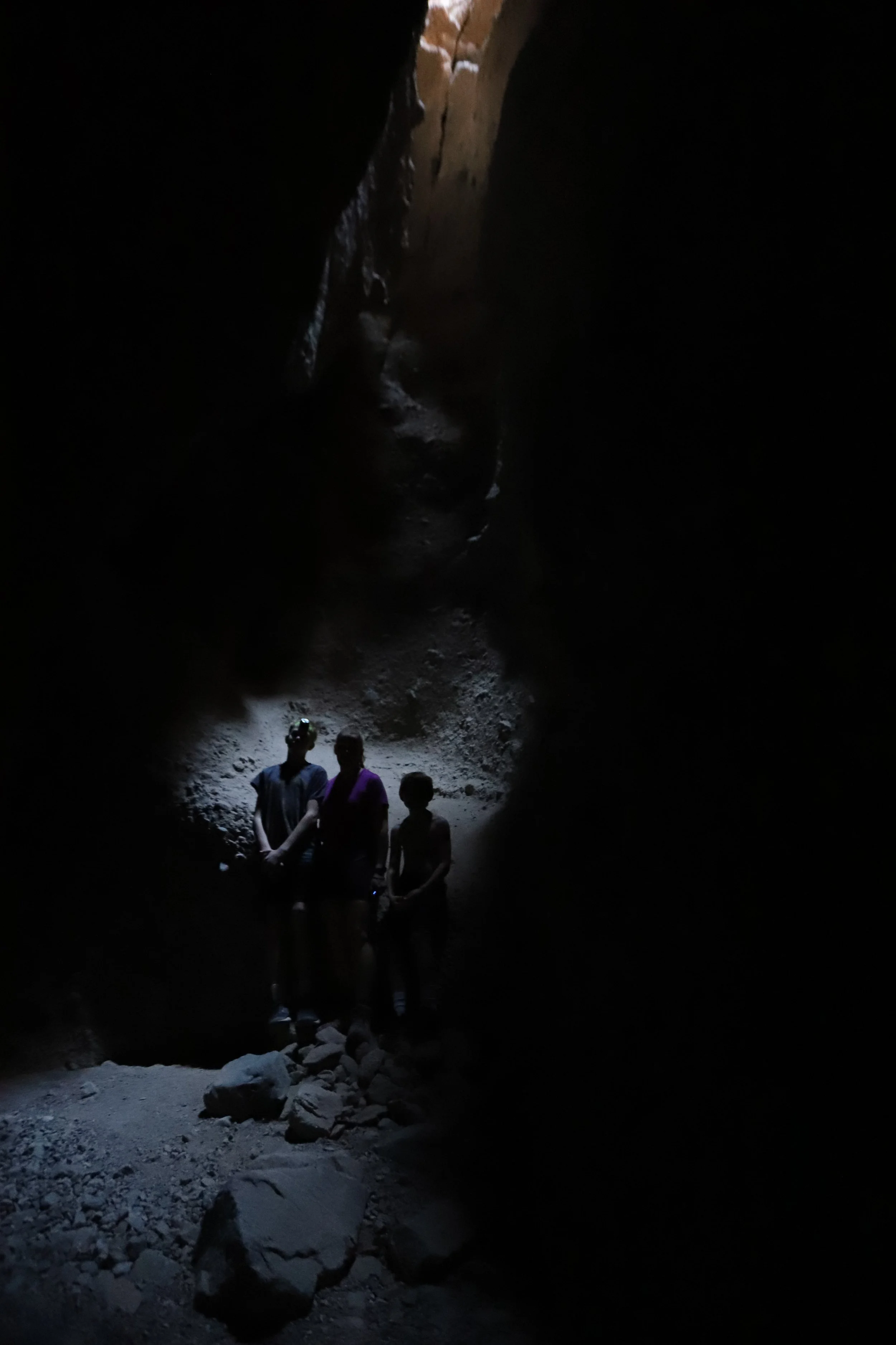
There are a few parts of this slot canyon that are tight. We’d read that ahead of time and just left our bags at the entrance. A second tip is to consider packing a headlamp if you have one. There were a few spots in this slot canyon that were pretty dark. Phone lights work ok too, it’s just awkward to hold them sometimes.

This was our favorite slot canyon to explore
This slot canyon has a hard end in the below picture, so you will know when you need to turn around.
The end of this slot canyon
The next slot canyon is about 1/4 mile from the previous slot canyon (or 1.25 miles from the parking lot). We didn’t have time to explore this canyon, but by now you’ll know what you are looking for regarding an entrance to a slot canyon. There’s a big Y in the canyon. The entrance is going to be on your right. This slot canyon will not have a formal end, so you can turn around when you want.
To get to the last slot canyon, hang a left at the Y and keep walking another 1/4 mile.

Hanging out inside the last slot canyon
Similarly, the last slot canyon does not have an end either. It opens back up into a different part of Sidewinder Canyon. We turned around at this point.

Inside the last slot canyon
It’s about 1.5 miles back to your car from the last slot. If you climb up the rocks a bit, you can get a really pretty view of the Badwater Basin.

Badwater Basin view from Sidewinder Canyon
2 - Badwater Basin / Badwater Salt Flats (lowest point in elevation in North America)
Distance - 1 mile to the polygon shapes (and 1 mile back)
Elevation Gain - N/A
Trailhead Location - If you are coming from Sidewinder Canyon, it is just under 30 minutes. If you are driving from the Furnace Creek Visitor Center, it’s about 20 minutes.

2 - Badwater Basin / Salt Flat, 3 - Natural Bridge, 4 - Devil’s Golf Course, 9 - Dante’s View
You won’t need any help navigating to the Badwater Basin Salt Flats. There is a large parking lot and a lot of people. In fact, this was the only place in Death Valley where there was a crowd of people. This was the of the reasons it was not our favorite place in the park. However, you will need to stop here to get a picture of the elevation sign.

Badwater Basin - Lowest point in elevation in North America at 282 feet below sea level
There isn’t a formal trail here, in fact you can wander about anywhere by foot in Death Valley. If you want to see the polygon shapes, you will follow the white salt about a mile before they appear. We stopped a half mile before that. Adjusting from the winter of Minnesota to the heat of Death Valley, the low elevation, and the extreme dryness in less than 48 hours was more difficult than you're probably imagining. We were hot and tired, and the scenery is all the same because it’s just flat. Had we realized the polygon shapes were just a half mile further, we might have continued, but I’m not sad about missing this. We were all really excited to get back to the air conditioned car.
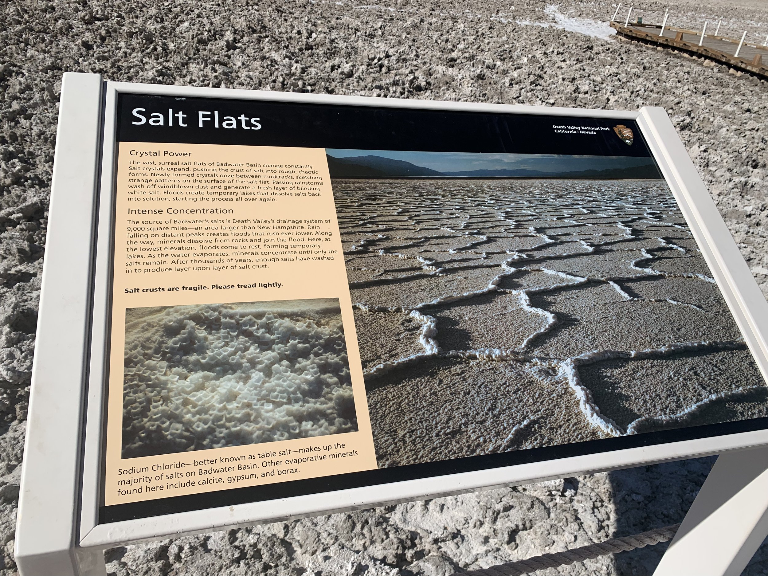
Salt Flats
Below is the view of the salt flats as you walk across them.

Salt Flats in the Badwater Basin
3 -Natural Bridge
Distance - 1 mile out and back
Elevation Gain - 180 ft
Trailhead Location - The parking lot for National Bridge is less than 5 minutes from Badwater Basin Salt Flats

2 - Badwater Basin / Salt Flat, 3 - Natural Bridge, 4 - Devil’s Golf Course, 9 - Dante’s View
The parking lot for Natural Bridge was full and we weren’t interested in a busy hike, so we skipped this one. If we return to Death Valley, this is a hike I would like to try. Due to it’s close proximity with the Badwater Basin Salt Flats, Natural Bridge is a popular hike, and is probably best to do early in the morning before the crowds.
4 - Devil’s Golf Course
Distance - N/A - This will likely be just a short wander out of your car
Elevation Gain - N/A
Trailhead Location - The parking lot for Devil’s Golf Course is 15 minutes from the Badwater Basin Salt Flats or 16 minutes from the Furnace Creek Visitor Center

2 - Badwater Basin / Salt Flat, 3 - Natural Bridge, 4 - Devil’s Golf Course, 9 - Dante’s View
Devil’s Golf Course is a really cool quick stop to make. First, it’s close to the Badwater Salt Flats but not near as busy. Second, there’s no trail so likely this is just a 10-15 minute stop. Third, the salt formations are strange and beautiful.
This is not a place to wear flip flops. The salt is hard and sharp. You would not want to fall here.

Salt Formations at Devil’s Golf Course

Devil’s Golf Course
To see the crystal, you’ll need to wander out a ways past where others commonly have walked, as footsteps ruin the beautiful structures.
Even though we were traveling in a pandemic, I’ll admit that we all tasted the rocks and yes, they are salt. It was a little funny to think of salt in any shape other than just as grains within a salt shaker.

Salt Crystals at Devil’s Golf Course
5 - Artists Palette
Distance - There are three pullouts. The longest walk was 0.5 miles.
Elevation Gain - The first pullout was the longest walk with 0.5 miles and 153 ft in elevation gain. There is zero elevation gain in the other two places to stop.
Trailhead Location - Artists Palette is a one-way road. The entrance to the is road is about 15 minutes from both Furnace Creek Visitor Center and Badwater Basin Salt Flats.

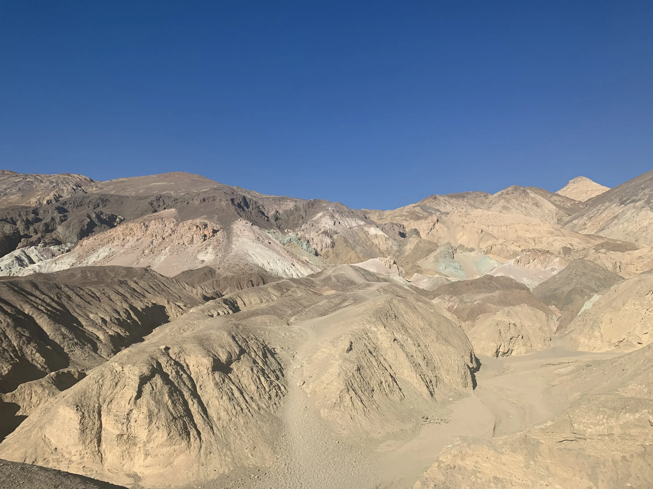
5 - Artist’s Pallete, 6 - Golden Canyon, 7 - Badlands Loop / Zabriskie Point, 8 - Twenty Mule Team Canyon, A - Furnace Creek
When you type in Artists Pallete into Google Maps, it will give you a pin in the middle of the one-way drive. This doesn’t correlate with any of the parking areas. There are three places to park. The first requires a 0.5 mile walk up 153 ft. This gives you a nice viewpoint of the whole colorful mountain as shown in the first picture.

View of Artist’s Palette from the first parking lot
I didn’t understand the second parking lot, unless it is an overflow parking lot. You can get a little closer to the mountain, but the way to get closer to the mountain is obstructed by a ravine. I wouldn’t suggest stopping.
The last parking lot is the best. This parking lot also has pit toilet, if you are looking for one at this point in your day. It’s a flat short 2-3 minute walk, and the trail gets you right up to the mountain to see the amazing green rocks as visible in this second picture.

View of Artist’s Palette from the last parking lot
6 -Golden Canyon
Distance - Approximately 2 miles
Elevation Gain - 215 ft
Trailhead Location - The trailhead to Golden Canyon is just 5 minutes from the Furnace Creek Visitor Center, and it’s 15 minutes from Badwater Basin Salt Flats.

5 - Artist’s Palette, 6 - Golden Canyon, 7 - Badlands Loop / Zabriskie Point, 8 - Twenty Mule Team Canyon, A - Furnace Creek
Golden Canyon forms a large 7-mile loop that includes Red Cathedral, Badlands Loop and Gower Gulch. Ambitiously, when planning our Death Valley trip, I intended that we hike this entire loop. A combination of both wanting to see other parts of the park and still adjusting to the heat resulted into us breaking this long loop into a 2 mile hike out and back into Golden Canyon and a 2.6 mile loop through the Badlands using the Zabriskie trailhead. I’m sure we missed cool things in-between, but this was a better fit for our trip.

Entrance into Golden Valley
We wandered about a mile into Golden Valley. This was an amazing part of Death Valley, and for how centrally located this trail is to the visitor center, it surprised me there weren’t more people on it.

Red Cathedral off in the distance

Wandering through Golden Canyon
Several scenes on the planet of Tatooine in Star Wars IV and VI were filled onsite in Death Valley. These sites are not marked along the trails, but supposedly somewhere along the Golden Canyon trail is where one of the scenes was filmed. In preparation for our trip, we watched all of the Star Wars movies, and yes, we were the family that packed light sabers in our luggage (they were even allowed in our checked bags through airport security).

7 - Zabriskie Point / Badlands Loop
Distance - 2.6 miles
Elevation Gain - 354 ft
Trailhead Location - The trailhead to the Badlands Loop starts at Zabriskie Point. This is 8 minutes from the Furnace Creek Visitor Center.

5 - Artist’s Palette, 6 - Golden Canyon, 7 - Badlands Loop / Zabriskie Point, 8 - Twenty Mule Team Canyon, A - Furnace Creek
If you don’t have time for a hike, then at least stop at Zabriskie Point to see the view. Note, there is a hike up a short hill to get to the viewpoint in case mobility is an issue.
Not much for plant life along this trail, however the varied colors in the rocks make up for it.

Beginning portion of the Badlands Loop
The trail starts off a little blah, but quickly gets amazing. Like most canyons, the trail first goes down and comes up at the end. Make sure you have enough water and snacks to get back.

Beginning of Badlands Loop
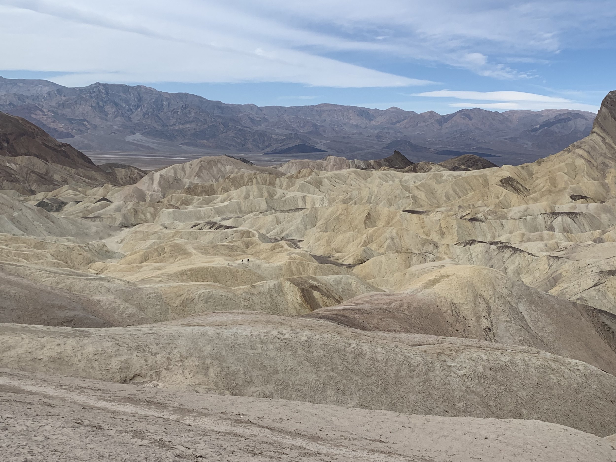
Badlands Loop
As you can see, it’s incredible! The rocks feel a lot like the crumbly rocks at Badlands National Park in South Dakota.

Badlands Loop

How can you not take pictures of this?

Badlands Loop

Badlands Loop
The trail back up will primarily be in a wash that looks like this. Watch for the sign back to the parking lot.
Another callout for using GAIA - we pre-download the hikes and can make sure we are on the right trail. It especially helps when you are in desert washes, that often look a lot like trails.
One last note on this hike is that as a reminder, it is part of the 7-mile loop to Golden Canyon. Make sure you are closely following the signs so you don’t end up on the 7-mile loop in error.

Wash in Badlands Loop that takes you back up the canyon
8 - Twenty Mule Team Canyon
Distance - N/A - This is a one-way drive. There are not easy places along the road to pullout.
Elevation Gain - N/A
Location - The one-way road begins 9 minutes from the Furnace Creek Visitor Center.

5 - Artist’s Palette, 6 - Golden Canyon, 7 - Badlands Loop / Zabriskie Point, 8 - Twenty Mule Team Canyon, A - Furnace Creek
Because there weren’t easy pullouts, I don’t have any pictures to share of Twenty Mule Team Canyon, although, thinking about it now, we were the only ones on the road, we could have just stopped and gotten out of the car. Regardless, we really enjoyed this neat canyon with yellow rocks. And sometimes it’s nice to just live in the moment, without simply seeing it through a lens.
Somewhere along the road is where Jabba the Hutt’s place scenes were filmed. We weren’t exactly sure where though.
One other thing to note is that this is a dirt road. It’s only 2.5 miles, and when we there the road conditions were great, but you may want to check with a ranger before heading out on it.
9 - Dante’s View
Distance - Up to 1 mile out and back
Elevation Gain - Up to 220ft
Location - Dante’s view is a 45 minute drive from the Furnace Creek Visitor Center, and 30 minutes from Zabriskie Point

A) Furnace Creek, 2) Badwater Basin / Badwater Salt Flats, 3) Natural Bridge, 4) Devil’s Golf Course, 5) Artist’s Palette, 6) Golden Canyon, 7) Zabriskie Point / Badlands Loop, 8) Twenty Mule Team Canyon, 9) Dante’s View
Dante’s View is a viewpoint of the Badwater Basin from above in the Black Mountains. As you can see from the map, to get to Dante’s View, you will need to go back out to CA Hwy 190, go past Zabriskie Point, turn right onto Furnace Creek wash rod and then onto Dantes View Road. Due to the extra time needed to get to the viewpoint, we skipped it to instead reach the Manzanar Japanese Internment Camp (near the eastern park entrance) before it closed. On a future trip though, this is the first place I want to head to.
There are views from the parking lot, and there is an additional trail to walk along for about 0.5 miles.
10 - Harmony Borax Works
Distance - 0.2 mile loop
Elevation Gain - N/A
Location - Harmony Borax Works is less than a 5 minute drive north of the Furnace Creek Visitor Center.

A - Furnace Creek Visitor Center, 10 - Harmony Borax Works, 11 - Salt Creek Interpretive Trail
The short loop around Harmony Borax Wells is interesting if you want to see a little bit of the mining history of Death Valley without exerting too much effort. Being honest, I’m not sure that I yet understand quite what borax is. It has something to do with salt, but not the salt that you eat, it’s used in chemicals.

Harmony Borax Works Interpretive Trail
While you are in Death Valley, you will see reference to the twenty mule teams. Teams of twenty mules would pull these wagons full of borax out of Death Valley to where they could be sold.

Wagons which carried borax were pulled by twenty mule teams
11 - Salt Creek Interpretive Trail
Distance - 0.8 mile out and back with a loop
Elevation Gain - N/A
Location - The Salt Creek Interpretive Trail is a 20 minute drive north of the Furnace Creek Visitor Center.

A - Furnace Creek Visitor Center, 10 - Harmony Borax Works, 11 - Salt Creek Interpretive Trail
When I imagined what Death Valley looked like, I can assure you I did not guess there were creeks or waterfalls. There is some water though in certain places in the park. Salt Creek is one of them, and although this trail was short, I loved it!

Salt Creek Interpretive Trail
The trail is a boardwalk that runs next to the Salt Creek. I have a 650ft boardwalk through wetlands at my house, so I won’t lie, I kind of have a thing for boardwalks. But that aside, this was a beautiful trail to see the water flowing through the desert.

Salt Creek in Death Valley
Once you are on the boardwalk, you’re going to get onto it and lean over to look closely into the water. You’ll notice little, tiny fish, pupfish, swimming. They are a little bigger than a tadpole, and smaller than a minnow. And somehow, they have evolved to withstand saltier conditions than the ocean to live here. These pupfish were one of my favorite things I saw at Death Valley National Park.

Peering into Salt Creek to watch the pupfish

Here are the pupfish!
In addition to the pupfish, the trail is pretty incredible too.

Salt Creek

Salt Creek Interpretive Trail
12 - Ubehebe Crater
Distance - N/A view from parking lot, or up to a 1.8-mile loop around the crater
Elevation Gain - N/A
Trailhead Location - The parking lot for Ubehebe Crater is approximately a 75-minute drive north of Furnace Creek Visitor Center

B) Stovepipe Wells, 12) Ubehebe Crater, 13) Mesquite Flat Sand Dunes, 14) Grotto Canyon, 19) Racetrack Playa
Death Valley tip - Hike in the morning and the evening, and in the afternoon when it’s hot, get in the car and drive some place in the air conditioning. I love hiking, but the drive to Ubehebe Crater was a really nice break. Unfortunately, with Scotty’s Castle still closed, there isn’t anything else to do in this northern part of the park, other than to see the crater after you’ve put in the effort of driving up here (unless you are brave enough to head out on the unmaintained dirt road to Racetrack Playa).
You can easily see the view I have shown below in the pictures just a few steps from the parking lot. If you want, you can walk into the crater. It’s a pretty big hole though. I’m not sure it looks fun to climb out of. There is also a 1.8 mile trail to walk around the big hole. That didn’t sound super exciting to me either. There is a smaller crater that you can view from the trail if you follow it a short ways. When we visited, it was extremely windy, so we just enjoyed the incredible view for 15 minutes or so and then we headed back south in the park to watch the sun set at the Mesquite Sand Dunes.

Added a picture of us for perspective. This is a really big hole. If you are curious, it was not created by impact, but rather by an explosion of volcanic steam.

13 - Mesquite Flat Sand Dunes
Distance - The sand dunes are about 0.5 miles from the parking lot. How far you want to explore into the sand dunes will determine how far you walk. There is no trail.
Elevation Gain - Dependent on how far you explore and how many times you run up and down the sand dunes
Trailhead Location - The parking lot is a 30 minute drive west of the Furnace Creek Visitor Center. If you stope for supper at Stovepipe Wells, it’s just a 4 minute drive.

A) Furnace Creek, B) Stovepipe Wells, 10) Harmony Borax Works, 11) Salt Creek, 13) Mesquite Flat Sand Dunes, 14) Grotto Canyon, 15) Mosaic Canyon
If I had to pick a favorite spot that we visited in Death Valley, it would the Mesquite Sand Dunes. We first had a really nice supper in Stovepipe Wells. We were able to eat outside (a treat in March for Minnesotans), and the food was great. After supper, we drove the short distance to the sand dune parking lot. We found a spot on one of the dunes to watch the sun set. While waiting, we ran up and down the sand dunes too many times to count.

Mesquite Sand Dunes at sunset
Although you can’t see many people in our pictures, there were people behind us. Several brought folding chairs. We were all there to watch the shadows grow long as the sun sets. There was beauty in watching so many people appreciating the simple daily routine of the sun.

Mesquite Sand Dunes

Should have remembered those light sabers…
As the sun was setting, my youngest decided he really wanted to climb that far off sand dune. They made it there and back in the last rays of sunlight.

Mesquite Sand Dunes

Mesquite Sand Dunes
The sun set, and everyone left. So we stayed. And for an hour or so while we watched the sky grow dark and the moon rise, we had this little spot in the desert all to ourselves.

Mesquite Sand Dunes
The timing of the moon rise and setting messed up our opportunity to see the dark skies of Death Valley, but we did have fun playing on the dunes and taking pictures in the moonlight.

14 - Grotto Canyon
Distance - 2.1 miles (out and back)
Elevation Gain - 675ft
Trailhead Location - The trailhead is 30 minutes from the Furnace Creek Visitor Center or 3 minutes from Stovepipe Wells.

A) Furnace Creek, B) Stovepipe Wells, 10) Harmony Borax Works, 11) Salt Creek, 13) Mesquite Flat Sand Dunes, 14) Grotto Canyon, 15) Mosaic Canyon
My initial plan for day 3 of Death Valley was Dante’s View, Grotto Canyon, Mosaic Canyon, and Darwin Falls. However, my husband is a history teacher, and as I mentioned earlier, when he realized how close we were going to be to the Manzanar Japanese Internment Camp, he wanted to get there before the park closed. So Dante’s View and Grotto Canyon were cut from our day. As I was planning out this hike though, it looked like a nice place to explore. Next time…
15 - Mosaic Canyon
Distance - 3.65 miles (out and back)
Elevation Gain - 900ft
Trailhead Location - Mosaic Canyon is 40 minutes from the Furnace Creek Visitor Center and 10 minutes from Stovepipe Wells.

A) Furnace Creek, B) Stovepipe Wells, 10) Harmony Borax Works, 11) Salt Creek, 13) Mesquite Flat Sand Dunes, 14) Grotto Canyon, 15) Mosaic Canyon
Mosaic Canyon is a really beautiful hike. There are sections like the first picture below that are of a pretty wide canyon, and then there are several sections where the walls tighten. This would not be a canyon to hike in if there was any rain.

Mosaic Canyon

Mosaic Canyon
About the first 1/2 to 2/3 of the hike is a pretty easy walk, although there is a steady incline. After this point, there are some significant rock scrambles that are required.

Mosaic Canyon
When I say rock scramble, I do mean that you will need to use both of your arms to climb up and slide down portions of the last part of the trail. In the below picture, we are sitting on the trail, not a side rock. Personally, with boys this age, these are the trails that we have the most fun on.

Mosaic Canyon
The trail is pretty straight forward until the end. If you are paying attention, you will notice some large arrows that people have designed out of rocks on the trail and they point towards the right. If you miss these arrows, you will come up to a high wall that you can’t pass. See the below picture, as we made this mistake.

False trail ending
On your way back to the trail, look for these arrows and follow them. There’s still a bit more to the hike. The pictures below are the true ending of the trail.

End of Mosaic Canyon trail is that shear wall on the right.

End of Mosaic Canyon Trail
16 - Wildrose Charcoal Kilns
Distance - N/A - Beehive structures are visible from your vehicle
Elevation Gain - N/A
Trailhead Location - The kilns are a 90 minute drive (each way) from the Furnace Creek Visitor Center

A) Furnace Creek, B) Stovepipe Wells, 4) Devil’s Golf Course, 5) Artist’s Palette, 6) Golden Canyon, 7) Zabriskie Point / Badlands Loop, 8) Twenty Mule Team Canyon, 10) Harmony Borax Works, 11) Salt Creek, 13) Mesquite Flat Sand Dunes, 14) Grotto Canyon, 15) Mosaic Canyon, 16) Charcoal Kilns
Similar to Ubehebe Crater, the Wildrose Charcoal Kilns would be best visited during the afternoon when you need a break from hiking. We saw some of Death Valley’s mining history at the Ashford Mill (near Salsberry Pass) and the Harmony Borax Works Interpretive Trail, so 3 hours seemed like a lot to spend on a drive to see these man made structures, granted the beehive shapes do look interesting. We will need to prioritize this site on a return trip.
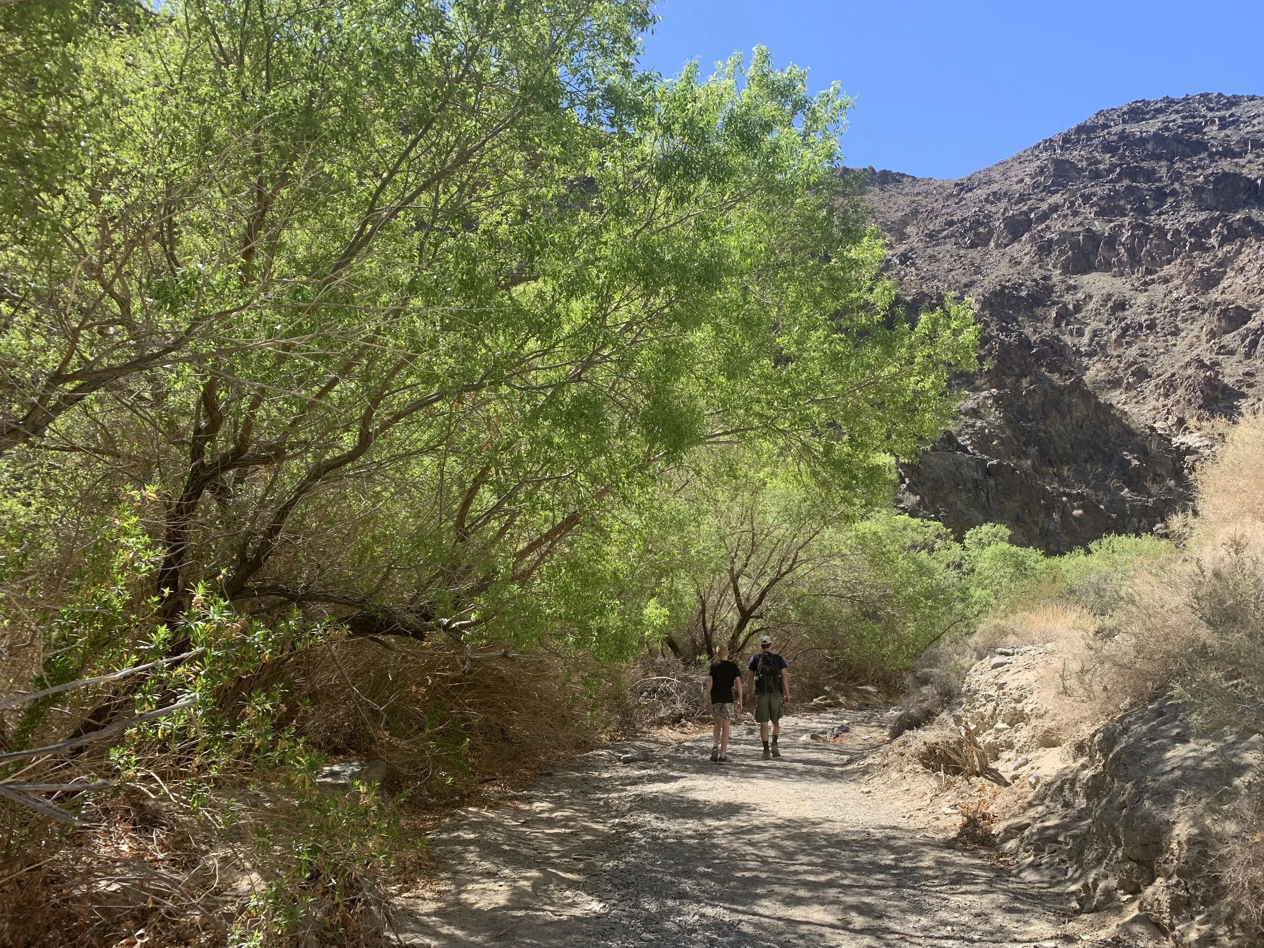
17 - Darwin Falls
Distance - 2 miles (out and back)
Elevation Gain - 200ft
Trailhead Location - The trailhead for Darwin Falls is 1 hour and 15 minutes west of the Furnace Creek Visitor Center. This trail is close to the west entrance of the park. There is a service station in Panamint Springs, just 15 minutes from the trailhead, and there are ice cream treats that can be purchased out of a freezer in the gas station. One other thing to note about the trailhead to Darwin Falls is that it is a dirt road, mildly maintained. There were some decent sized rocks and potholes to navigate. We rented a mid-sized SUV and felt pretty comfortable on this road with the larger sized wheels.
B) Stovepipe Wells, C) Panamint Sprints, 13) Mesquite Flat Sand Dunes, 14) Grotto Canyon, 15) Mosaic Canyon, 16) Charcoal Kilns, 17) Darwin Falls, 18) Star Wars Canyon
Like the other trails in Death Valley, Darwin Falls starts off without any shade - just so you are prepared, bring water and sunscreen even though you are headed to a waterfall.

Beginning of Darwin Falls Trail
Eventually, there will be a small creek that runs along the left, and all of sudden, there are green trees flourishing in Death Valley, which again, surprised me.
Darwin Falls Trail
As far as waterfalls go, Darwin Falls is small in height, and although we were there in March, there was more water than I expected, but I wouldn’t call it a gushing waterfall. But I was really impressed at the diversity of Death Valley National Park, and if that interests you, then I would suggest this hike. It reminded me a lot of the Roaring Springs in the Grand Canyon, where the water seems to just pour out of the rocks, and you stare at it, wondering where it came from.

Darwin Falls

Right across from Darwin Falls
18 - Star Wars Canyon
Distance - N/A
Elevation Gain - N/A
Trailhead Location - Star Wars Canyon (Rainbow Canyon) is off of a dirt road from the Father Crowley Overlook on the western edge of the park (15 minutes from Panamint Springs).

B) Stovepipe Wells, C) Panamint Sprints, 13) Mesquite Flat Sand Dunes, 14) Grotto Canyon, 15) Mosaic Canyon, 16) Charcoal Kilns, 17) Darwin Falls, 18) Star Wars Canyon
I had not heard of Star Wars Canyon until we were in Death Valley. I looked it up when I heard the name as I was wondering if they had filmed the movies at this site. They did not. But it’s a site that the military flies their jets near, so photographers often come here to take closeup pictures of the jets. Timing on when the jets might be practicing would be hard to guess, so if this sounds interesting to you, just make sure to give yourself time to wait and be patient. We were running off to Manazar at this point at the end of our Death Valley journey, so we didn’t venture down the dirt road from the Father Crowley Overlook. Certainly though, we will stop here on a return visit.
19 - Racetrack Playa (sliding rocks)
Distance - N/A
Elevation Gain - N/A
Trailhead Location - The Racetrack Playa is approximately 2.5 hours drive from the Furnace Creek Visitor Center (one way). From Ubehebe Crater, the road switches from paved to an unmaintained dirt road.

B) Stovepipe Wells, 12) Ubehebe Crater, 13) Mesquite Flat Sand Dunes, 14) Grotto Canyon, 19) Racetrack Playa
If you have seen pictures of the sliding rocks or “sailing stones” of Death Valley, they are located at the Racetrack Playa. If you haven’t seen these images, google “Racetrack Playa”. These pictures will bring me back to Death Valley someday, once I’m brave enough to try the unmaintained dirt road, or have someone else willing to head out there with me in a separate car, in case somethings happens.
If you have been to the Racetrack, can you please leave me a comment below? How was the road? What di you do to prepare for a safe trip? I’d appreciate the tips.
Other Nearby Places
Heading to Death Valely and wondering what’s nearby? Here are some ideas.
Manzanar National Historic Site

Manzanar Japanese Internment Camp
Manzanar is about an hour and 15 minutes from Panamint Springs, and it’s only an extra 30 minutes of driving if you are heading to or from Los Angeles. This is one of the camps that Japanese Americans were forced to live in during World War 2. There is a nice visitor center with a lot of information, and they have restored some of the barracks, mess hall, bathrooms, school, and some of the recreation places so you can get a feel for what life was like here. I learned more here than I ever did in history class.
Mount Whitney Trailhead
The same geological forces that created the lowest elevation also created the highest elevation in the United States. Although it is just a two and a half hour drive between Badwater Basin and the trail that leads to the top of Mount Whitney, the time of year you can hike Mount Whitney is the opposite time that you want to visit Death Valley. Despite their geological closeness, plan two separate trips to enjoy these wonders.
Joshua Tree National Park
See the below link for a guide to plan your trip to Joshua Tree National Park. If you are planning a loop road trip from Las Vegas, Joshua Tree makes a great destination on your return.

Mojave National Preserve
We saw the Kelso Sand Dunes off in the distance on our way back to Las Veags but didn’t have quite enough time to plan a day here. We will be back to climb these dunes on a future trip!
More from www.NatureImpactsUs.com
Posts are linked to each pin below.