

Beaver Creek - Beaver Creek Valley State Park
If you enjoy my blog, please consider signing up below to get email notifications of my latest posts. I will not share your email.

A Place to Grow Old
If you are looking for a quiet place to hike, check out Beaver Creek Valley State Park in the southeastern corner of Minnesota. It’s less developed and smaller than a lot of other MN State Parks, but I was still able to enjoy 8.5 miles of hiking on a fall day that I had taken off from work. I ran into less than 10 people in the entire park, despite it being a beautiful day in a beautiful place.
My favorite part of Beaver Creek Valley was all of the new benches placed everywhere around the park. Although my goal was to hike as much of the park as possible rather than actually sit on one of these benches, I made note of Beaver Creek Valley as a great place to stroll in the future. I intend to come back with my husband as we get older. The Beaver Creek Trail stays flat and meanders along the creek and through a meadow with plenty of places to sit and enjoy some time in nature. If you are looking for a bit of a challenge, there are also plenty of other trails to pick that climb up into the bluffs to give your legs a workout.

Beaver Creek Trail
Planning Your Trip
Beaver Creek Valley State Park is a 2.5 hour drive from both St. Paul and Minneapolis. This is doable in a long day, but it may be a better option to stay in Rochester or Winona (each are about an hour away) and add a second day of hiking at one of the other nearby state parks such as Great River Bluffs, Whitewater, Carley, or Forestville. (Scroll to the end for links to my posts of these parks.) Beaver Creek also has drive-in and cart-in campsites as well as cabins for rent. I did not see any showers in the bathrooms, but there were flushing toilets and sinks.

Beaver Valley Creek State Park Cabins
There is an entrance fee into Beaver Creek Valley. If you do not have the annual MN State Park Pass on your vehicle, there is a kiosk where you can pay for the day.
I would plan on a half day to see the best parts of Beaver Creek Valley State Park with approximately 4 hours of hiking.
One other thing to realize before you head out to Beaver Creek Valley is that you will likely not have cell phone service in the park. This means you will be able to use an app like Google Maps to get to the park, but you won’t be able to load directions when you leave from the park. Make sure you’ve planned out how to leave before you get to the park.

Beaver Creek Trail
See the below interactive map for additional places to hike in Minnesota and neighboring states. Use two fingers on the map to zoom in and out to look around. Links to blog posts for each pin are included.
Location and Parking Lot
As I mentioned, this state park is in the southeastern most part of Minnesota. You will likely come into the park from I-90, and then turn onto MN-76. County Rd 1 will take you into the park. It will feel pretty desolate the closer you get to this park. The lack of civilization is a huge part of this park’s charm. Comparing this park to nearby Great River Bluffs State Park, I liked Beaver Creek Valley much better due to the lack of any development. The only spot I could see civilization (one farm house) was from the bottom part of the West Rim Trail when the trail gets very close to the park boundary.
There’s only one parking lot, which makes this park easy to navigate. Across the parking lot, you will find a playground on one side, and picnic tables, seasonal access to water, and bathrooms on the other.
Trails lead you from both sides of the parking lot, so if you plan a loop around the entire park, such as following the Hiking Club trail, you will end up back at the parking lot in the middle of your hike. This isn’t a bad park design, because you will have the option of calling it quits if you are tired rather than wandering too far from your car and being “stuck” with a long hike back. There’s also the bathrooms that are situated near the parking lot so if you are hiking with kids this is fantastic as they will be available in the middle of your hike.
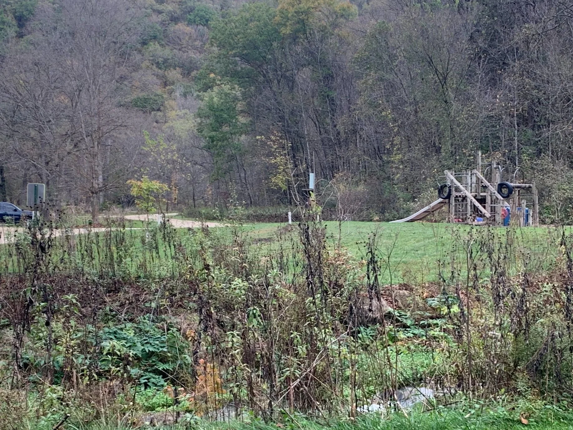
Playground at Beaver Creek Valley State Park

Picnic table and water (near the Beaver Creek Valley State Park parking lot)
Hiking at Beaver Creek Valley State Park
Note the parking lot is in the middle of the below map. I’ve colored the trails for ease in describing the various trails. These colors will not mean anything to you once you are hiking on the actual trails. I’ve also added trail distance estimates based on my GAIA app while I was hiking as the state park map doesn’t include mileage.
My high-level recommendations for hiking this park are the following:
1) Take the Beaver Creek Valley Trail (labeled just as Beaver Creek Trail in the park). This is the blue trail highlighted on the below map. This is a really easy trail from a mobility standpoint with lots of creek crossings along wide flat bridges and pretty views of the meadows in the valleys surrounded by bluffs.
2) Take Big Springs Trail (green) then cut back along the road towards the cart-in campsites (pink) and follow Hole in Rock Trail back. Really it’s just the Hole in Rock Trail I suggest you hike along due to the amazing views from the bluffs, and the hole is interesting. But out-and-back hikes are boring, so this is a nice loop. This is a more strenuous hike due to the elevation gain.
3) If you are looking to get into the bluffs one more time, take Switch Back Trail (purple). The views weren’t quite as good as from Hole in Rock, but the trail is fun with lots of mossy rocks.
Steep Rock Trail was closed for maintenance when I was there, so I wasn’t able to hike this one.
For pictures, trail distances, and elevation gain, read below for a review of each trail.

Beaver Creek Valley State Park Map with Mileage Estimates
Beaver Creek Trail (3.6 miles, elevation gain - N/A)
In the map above, I have Beaver Creek Trail highlighted in blue. The trailhead is west of the parking lot and you’ll pass by the bathrooms on the way to the trailhead.

Beaver Creek Trailhead
I’ve been on lots of trails labeled “creek” where the majority of the trail is either to get to the creek, or it simply crosses over the creek once or twice and then drifts quite far from the water. You will cross the creek right away and the majority of the trail stays quite close to the creek, which it crosses several times. The trail will spend a bit of time in a beautiful meadow away from the water, but for the majority of your hike you will be able to enjoy the sound of the creek moving over the rocks as you hike.
This is an extremely easy hike from a mobility perspective. The trail remains flat, the bridges which cross the creek are wide, there are beautiful new benches to sit everywhere, and if you need to turn around early, there are two different loop options to shorten the hike.

Beaver Creek

Beaver Creek Trail

Beaver Creek Trail
Beaver Creek Trail does separate from the creek for a moment and travels at the edge of a very pretty meadow where you get a view of the valley that you are in.

Beaver Creek Trail
You will return back to the creek for more hiking. There are several benches to stop and simply enjoy your surroundings at multiple places along Beaver Creek as well as throughout the entire park.

Beaver Creek Trail

Beaver Creek Trail
Plateau Rock (0.6 miles added as a spur hike from Beaver Creek Trail or 2.2 miles as a out and back, 200 ft in elevation)
Walk past this trailhead. Most of the trail is hard packed dirt which gets slippery when it’s wet. Parts of the trail lean in a slanted manner which made me really nervous, and there is zero view at the top as it’s all over-grown with trees. The best view from the bluffs is along Hole in Rock Trail.

Plateau Rock Trailhead
You will find the Plateau Rock trailhead along the Beaver Creek Trail. I’ve marked it as the red trail on the map above. It starts off pleasantly with some nicely maintained steps.

Stairs up Plateau Rock Trail
It’s hard to tell from the below picture, but this part of the trail is actually slanted while it continues to gain in elevation. I didn’t feel very safe on this trail and would not recommend it.

Narrow and slanted trail - Plateau Rock
The below picture is Plateau Rock. I was expecting something more than essentially just a rock at the top, covered in a forest.
Plateau Rock
This is the view from the top of Plateau Rock. I met another hiker at the top. It was so underwhelming that he had continued to hike quite a bit further looking for a better view, but when I talked with him, he conceded that he agreed, this was Plateau Rock.

View from Plateau Rock
There is a bench at the top near Plateau Rock, but nothing much of a view to look at here.

Plateau Rock
Although the trail is short, you can get an idea of how steep it is by looking at the below bridge.

Plateau Rock Trail elevation gain
Switchback Trail (0.6 miles added as a spur hike from Beaver Creek Trail or 1 mile as a out and back, 200 ft in elevation)
I have Switchback Trail shown in purple on my map. The park notes this trail as 2 miles out and back from the parking lot. I’m not sure if I ended the hike early at the top, but I thought I stopped at the end of the trail. I’m not sure why the park indicates the length of the trail is so much more than what I recorded while I was hiking. I can’t tell what mileage the park is estimating their numbers on as they don’t indicate it on the map itself.
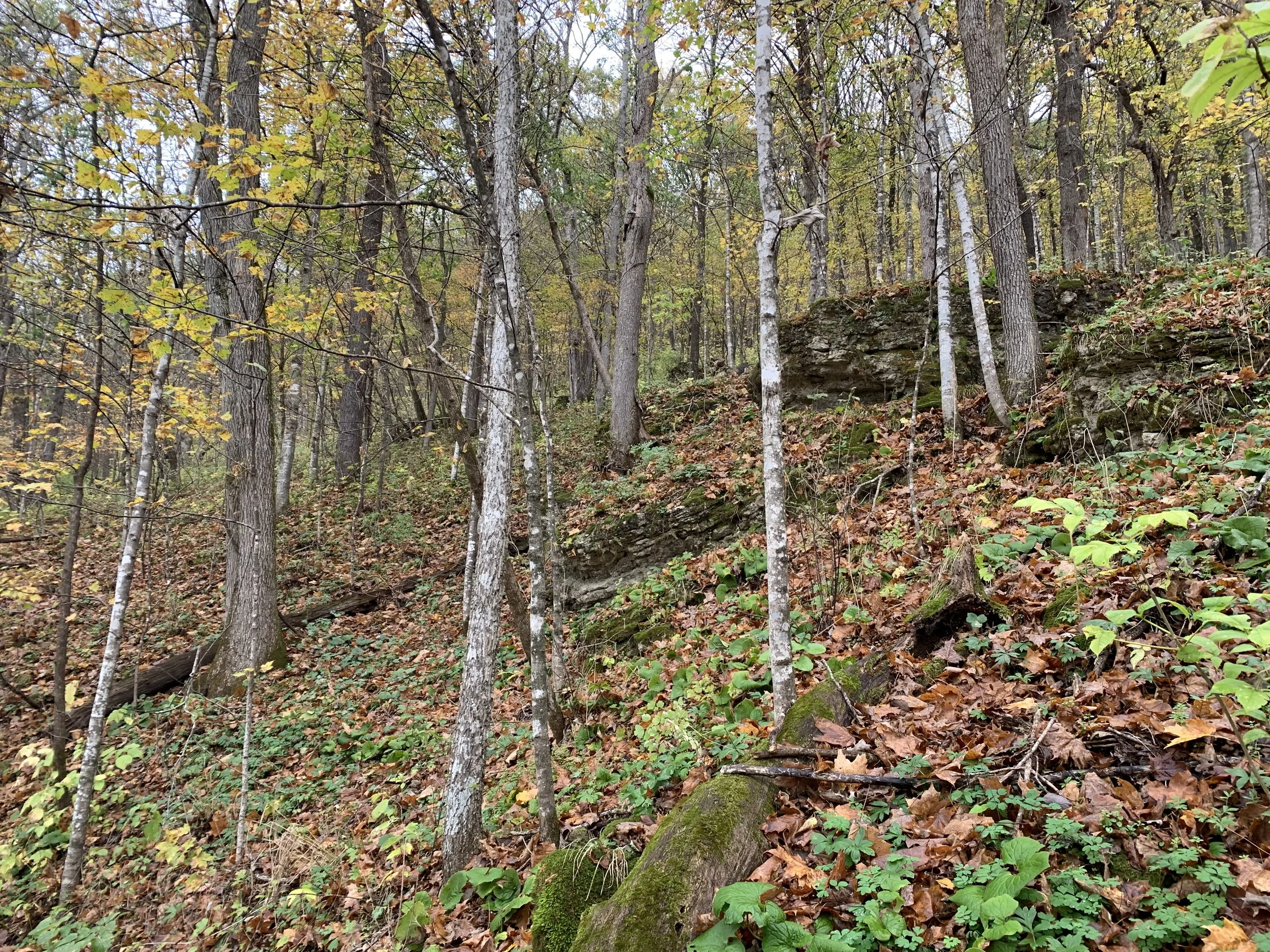
I enjoyed Switchback Trail. The views from the bluffs are better on Hole in Rock, but I liked the mossy rocks along the way. I think of rocks as being a constant on our planet, but you can see the forces of nature and physics at work on them with the plant growth and realize that everything changes, albeit at a slower rate than we are often able to notice.
This trail is nice and wide. There are steps made of rocks and wood, and just a few tree roots to navigate around. If you are looking to burn off a few extra calories, or want your kids to lose a bit more energy for a good night’s sleep, this is a great spur trail to add on.

Switchback Trailhead
The trailhead for Switchback Trail is clearly marked and starts off with some relatively easy steps.

Switch Back Trail stairs
Here are some of those huge rocks with moss growing all over them.

Bluffs on Switchback Trail
More mossy rocks. I’m not sure why, but the mossy rocks always make me think of fairies and fairy gardens.

Mossy rocks on Switch Back Trail
Below are the pretty views from the top. A little bit overgrown, but you can see more of the valley than the pictures show.

Switch Back Trail
This is a well placed bench with a beautiful view.

View from Switchback Trail
One more view from the top. I also enjoyed that there was a loop to take a different part of the trail on the way back.

View from Switchback Trail
Big Spring, West Rim, Hole in Rock (2.5 miles or 2 miles with the shortcut down the road near the cart-in campground, 400 ft in elevation)
To get to Big Spring from Beaver Creek Trail, you will first end up back at the parking lot. You’ll start on the trail behind the playground. It starts as a hiking trail between the parking lot and the campground.
I have this whole loop displayed as green on my map.
I hiked the whole distance of this loop, but ultimately wasn’t that impressed by the southern most part of West Rim. Honestly, I think it was the one farm house that I saw along the way that just for a moment ruined my sense of being all alone. I was hiking in October, so there wasn’t anyone in either the drive in or cart-in campgrounds. I really felt like I had this park to myself, so seeing a house was a little bit sad on this trail.
If you want to shorten the distance and save some steps, I would take the trail / road that I have marked in pink on the map. I don’t think you’d feel like you missed anything if you took this shortcut.

West Rim Trail - Beaver Creek Valley State Park
There is a nice meadow once you get a ways from the campground. The meadow along the Beaver Creek I felt was prettier with the bluffs on both sides, but this is nice hike too. And as you’ll see below, there really are park benches everywhere in this park, most aimed at nice views.

West Rim Trail - Beaver Creek Valley State Park
This is the house that just for a moment ruined my solitude. It’s not close by any means, but it’s the only sign you’ll see of other people when you are in this park.

West Rim Trail - Beaver Creek Valley State Park
On the southern part of West Rim, when you start to head down again on your way towards Hole in Rock, the trail gets further away from the park boundary. I was happy and stress-free again by this point, and this was my favorite part of the West Rim Trail. Again, more benches. You can tell I really liked them as I took pictures of so many of them.

West Rim Trail - Beaver Creek Valley State Park
After you descend from the rim, you’ll find yourself back in a thick forest.

West Rim Trail - Beaver Creek Valley State Park
As you get closer to the cart-in campgrounds, the trails start to crisscross a bit, and this is the only spot in the whole park I made an error - next to sites 50 and 51. You want to take the trail that goes past the port-a potties. If you find yourself in the cart-in campground, you’ve made a mistake.
Another shout out to my GAIA app. On the expensive side of apps, but this app quickly helped me figure out I had made a mis-step, and I turned around right away.

Spur trail to cart-in campground
Following the cart-in campground, the trail you are on will turn into the Hole in Rock Trail. I really enjoyed this trail, and I’m not sure if this was my favorite or if it was Beaver Creek. This trail goes up and down a lot, but the views are amazing, the trail is interesting, and there were several places that I loved feeling the magic of the trees and bluffs.

Hole-In-Rock Trailhead
If you come from the cart-in campground side of Hole in Rock, you will be greeted with amazing views right away as you ascend to the top. I thought these were the best views in the park.

View from Hole-In-Rock trail
I think this bench below is the best-placed bench in Beaver Valley Creek State Park.

View from Hole-In-Rock trail
This is a fun trail. There are bridges, steps, rocks, and tree roots to navigate.

View from Hole-In-Rock trail
There were so many points along Hole in Rock Trail that I honestly wondered to myself if some how I missed the hole in the rock. I guarantee you will not miss it. The trail will take you right past it, and the rock is big, as you can tell from the nearby trees.
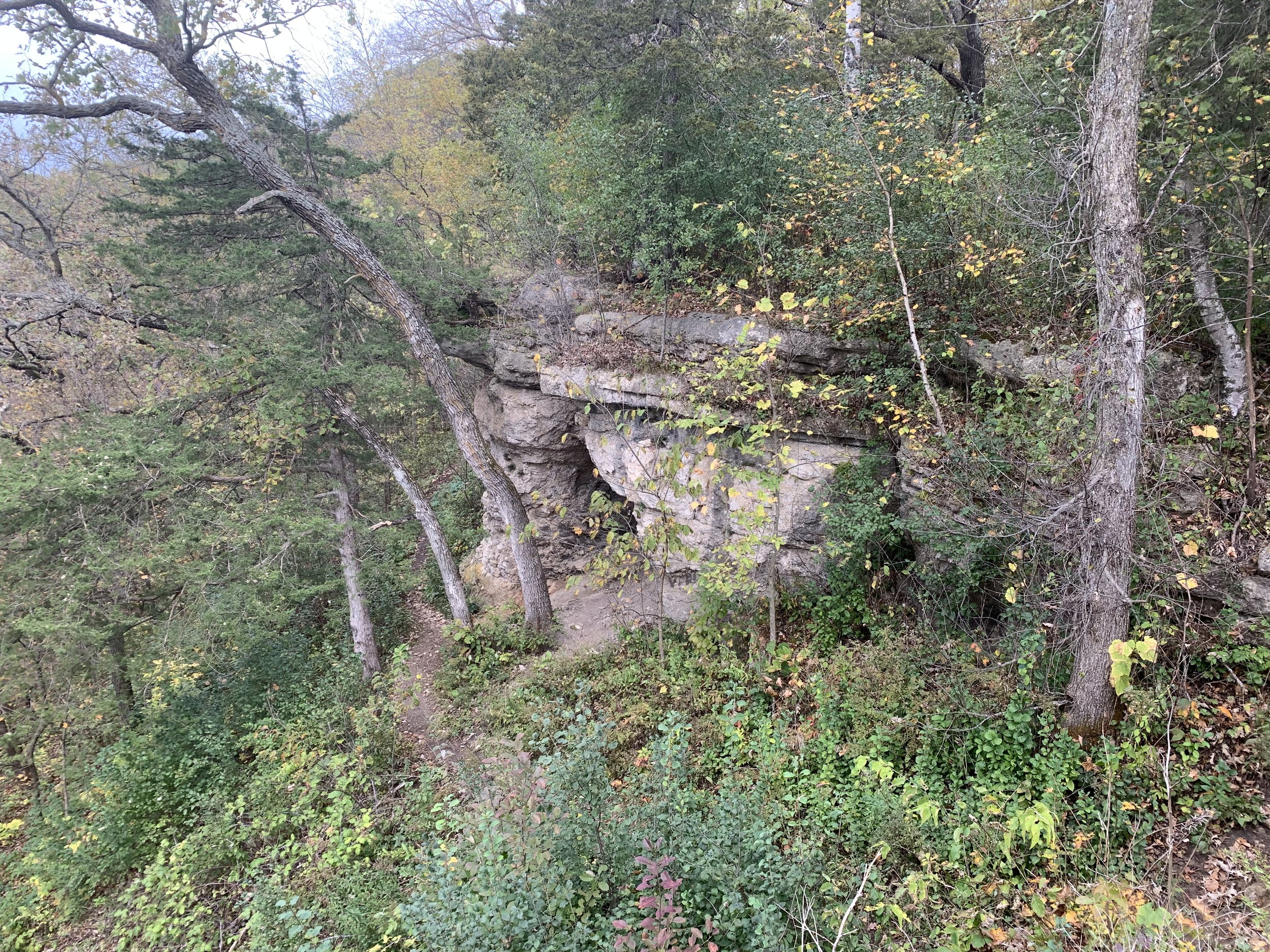
Hole in the Rock
Here is the hole. Hard to get a great picture of it as the trail is on the edge so you can’t back up any further.

Hole in the Rock - Beaver Creek Valley State Park
I enjoyed the colorful forest on my way back.

Hole-In-Rock Trail
Mossy Seep Trail (0.7 miles added as a spur hike from Hole in Rock, 200 ft in elevation)
I have the Mossy Seep Trail shown in brown on my map. This is another trail I would recommend skipping. I liked the first part (between Hole in Rock and the road). But you either need to finish the trail to get back to the parking lot (which I found very confusing and not at all scenic) or walk along the road. I’m not sure it’s necessary to take those extra steps along the road based on the fact you’ve already seen similar features along the Hole in Rock Trail.

Mossy Seep Trailhead
You’ll find the trailhead for Mossy Seep along the Hole in Rock Trail. As I mentioned above, I enjoyed this first part. Again, lots of mossy rocks and an interesting ravine.

Mossy Seep Trail
Mossy Seep next crosses the road. The trail is clearly marked from the road and I was able to follow it up the hill. I did get turned around for a moment at the top. It may have been due to the leaves covering the trail. Regardless, you can see the ranger station so you won’t get lost.

Continuation of Mossy Seep Trail across the street
I did laugh at this bench as I could not tell what it was meant to be aiming at. There wasn’t a view of anything at the top of this trail.

Mossy Seep Trail
This was the biggest rock I noticed in the park covered in moss. So if you are having fun with these rocks, then maybe consider adding this trail, but beyond this rock, I didn’t get much out of this trail.

Mossy Seep Trail
Other Things to Do Nearby
Great River Bluffs State Park (40 minute drive) - Nice park, although the views along the Mississippi River highlight development of the river and its watershed. A link to my blog post is included.

Carley State Park (45 minute drive) - Another very quiet and less developed park. If you love Beaver Creek Valley you will also love Carley. Link to my blog post included.

Carley State Park
Whitewater State Park (45 minute drive) - A busier park from a people traffic standpoint, but my favorite State Park in the southeastern part of MN. Link to my blog post included.

Whitewater State Park
Forestville / Mystery Cave (1 hour drive) - You’ll find interesting sink holes and a neat historic preserved town in Forestville State Park. Mystery Cave includes a nice tour that you can buy tickets for. When you look at the MN State Parks website it lists these two locations together, but note they are two different physical locations. If you get cave tour reservations, you need to be at the Mystery Cave Visitor Center.

Forestville State Park

Aqua pool inside of Mystery Cave
Niagara Cave (1 hour 10 minute drive) - The coolest part of this cave tour is a waterfall inside the cave. I like Mystery Cave better as an overall more interesting cave, but it’s an impressive waterfall inside Niagara. Hard to take as good as a picture though as the ones they have in their brouchures.

Niagara Cave
More from www.NatureImpactsUs.com
There are posts linked to each pin below.